Arun Valley Trek 14 Days

Tour Info

trip code

EN-40

Starting Point/ End Point

Kathmandu

Accommodations

Lodge/ Tea House

Max Altitude

2850m (Gurase / Sanam / Panggom Region)

Duration

14 days

country

Nepal

Trip grade

Moderate

Activities

Trekking , Flight and Tourism

Best Season

March, April, May, September, October, November

Overview

The Arun Valley trek takes you on one of Nepal's least crowded and most diverse trekking routes. It connects the lower eastern hills to the Everest region. This trip offers a unique combination of deep river canyons, traditional mountain villages, lush forests and panoramic Himalayan views. Arun Valley trek, which lasts 14 days, is perfect for those who want to experience the Himalayas in a way that's not as crowded. It begins in Kathmandu before moving eastwards towards Tumlingtar and then entering the picturesque Arun Valley. The trail winds through remote villages and terraced farmlands before connecting with Lukla, in the Everest area. This moderate trek combines both natural beauty and cultural immersion. It's perfect for those who want adventure as well as authenticity.

Details 

Arun Valley trek is a unique journey which links the low-altitude Arun River basin to the high Himalayan landscapes in the Everest region. The trail is known for its biodiversity and cultural diversity, which gives a unique perspective on Nepal trekking compared to other commercial routes.

The trek starts with a flight to Tumlingtar. From there, the ascent continues through Kartike before entering deeper into Arun Valley.  Arun Valley Trek trail passes through villages such as Gothey, Salpa, Phedi, Gurase, Bhanjyang and Sanam, where rural life is traditional, and the landscape is untouched. The terrain changes every day, from subtropical forest to alpine mountains.

The trail continues to Bung, Gai Khara, and Panggom. This route offers panoramic views of the distant Himalayan ranges and rolling hills. The route connects with Lukla and marks the entry into Everest before flying back to Kathmandu.

This is a less crowded trek that offers a culturally rich and diverse experience. It's a great alternative to the classic trekking routes of Nepal.
Highlights

  • Explore the hidden beauty of Nepal's Arun Valley.
  • Explore diverse landscapes, from low river valleys up to the high Himalayan ridges.
  • Discover traditional Rai and Sherpa villages along the trail
  • Enjoy a walk through the lush forest, terraced fields and remote mountain villages
  • Take in the panoramic views of Makalu and the surrounding Himalayan peaks.
  • Lukla is the ideal way to connect the Arun Valley with the Everest region.
  • Enjoy authentic rural Himalayan culture far from the crowded trekking routes.
  • Trek through multiple climate zones in a single trek
  • Reach Lukla to reach the Everest region
  • Fly back to Kathmandu for a scenic flight at the end of your journey

Itinerary

Day 1: Arrive at Kathmandu (1,347m/4,417ft)

Kathmandu is the vibrant capital city of Nepal. You will be welcomed at Tribhuvan International Airport and then transferred to your hotel. This drive gives you a glimpse into Nepal's colorful, busy local life, blending with temples and modernity. The remainder of the day can be spent relaxing in order to recuperate from your travel experience. Depending on your stamina levels, you can either decide to spend your time in the hotel or opt for an exploration tour of the surrounding neighborhood. The town of Kathmandu is a mixture of both craziness and spirituality. It is important to prepare your mind for the journey ahead into the far-flung Arun valley regions.

  • Max Elevation: 1,347 m
  • Travel Distance: Airport to hotel (short city drive)
  • Travel Hours: 20–30 minutes
  • Accommodation: 3-star hotel (Kathmandu)

Day 2: Kathmandu Sightseeing and Trek Preparation

Following breakfast, your guide will collect you from your hotel and will take you for a guided tour of the Kathmandu Valley using private transport. This will give you enough time at all destinations, as this itinerary is well thought out with sufficient time allocated at all places to provide a relaxed and enriching experience for you. Your guide will be there to explain the historical, cultural and religious importance of each location during this excursion, giving you more insight into the rich history of Kathmandu prior to the trek.

During your sightseeing, you’ll be visiting some UNESCO World Heritage Sites.

The Swayambhunath Stupa or Monkey Temple

It is a historic Buddhist structure located in Nepal. Known as an important site of pilgrimage, the stupa has gained its reputation owing to the presence of monkeys living here. Located on the top of a hillock, it gives a beautiful view of the Kathmandu valley. The stupa is richly ornamented with shrines and Buddha eyes, which represent wisdom and awareness. It is also festooned with prayer flags.

Pashupatinath Temple

Pashupatinath, located on the banks of the Bagmati River, is one of Hinduism's most sacred temple complexes. The temple has traditional pagoda architecture, shrines, and open cremation platforms on which Hindu religious rites take place every day. The area outside of the main temple can be visited by non-Hindus and provides a deep understanding of Nepalese culture and spiritual beliefs.

Boudhanath

Boudhanath is one of the largest Buddhist stupas in the world and acts as a center of Tibetan Buddhism in Nepal. It was built in the 5th Century and is known for its huge white dome, as well as the all-seeing eye of Buddha. Around the stupa are monasteries and shops as well as prayer wheels. Monks and pilgrims walk around clockwise, chanting their prayers.

Kathmandu Durbar Square

Kathmandu Durbar Square, a historic royal compound, is filled with ancient palaces and courtyards. It also contains temples and Newari architecture. It used to be the capital of the Malla Kings and currently serves as a museum for the culture and art of Nepal. This square contains some of the most beautiful wood temples and pagoda architecture, which is the embodiment of years and years of tradition and skill.

After the tour, you can spend the rest of the day at your hotel. Take your time and enjoy!

  • Max Elevation: 1,450 meters (Swayambhu Stupa, highest point in the Kathmandu sightseeing tour)
  • Travel Distance: 25 to 30 kilometers (total driving between sites)
  • Travel Hours: 6 to 7 hours
  • Accommodation: 3-star hotel
  • Meals Included: Breakfast 

Day 3: Flight to Tumlingtar and trek to Kartike (523m/1,715 ft)

Early morning flights from Kathmandu will take you to Tumlingtar. You'll enjoy stunning views of distant Himalayan peaks, rivers and hills. As soon as you land, your trekking adventure begins in the lower Arun Valley region. The trail takes you through rural villages and terraced farms, as well as forested paths, where the pace of life is slow and traditional. Arun River basin is a humid and warm environment. It is a peaceful and green environment with occasional views of the hills. The trail leads you gently towards Kartike village, a peaceful village surrounded by beautiful natural landscapes. This is the first stop of the day on the trail and marks the beginning of the long trek into the remote mountainous regions in eastern Nepal.

  • Max Elevation: 523 m (Kartike)
  • Travel Distance: Kathmandu to Tumlingtar (flight) + trekking to Kartike
  • Travel Hours: Flight + 4–6 hours trek
  • Accommodation: Tea house / lodge
  • Meals Included: Breakfast, Lunch, Dinner

Day 4: Kartike to Gothey (1,128m/3,700 ft)

The day's trek begins with an ascent through forest and rural villages that dot the countryside. Along the way, there will be bird songs, running rivers and scenes from nearby villages. You will have to traverse terraced farmlands, small hillside dwellings, and locals still engaging in traditional agricultural methods. Vegetation increases as you climb higher, coupled with cooler temperatures. The slope is not too steep, which allows the traveler to explore the Himalayas at their own pace. There are also times when there is a break from the woods, where travelers can catch glimpses of the hills and valleys around them. Upon reaching Gothey, travelers can expect to arrive there in the evening. Gothey is a picturesque spot, bestowed with all that nature has to offer.

  • Max Elevation: 1,128 m
  • Travel Distance: Approx. 10–12 km
  • Travel Hours: 5–6 hours
  • Accommodation: Tea house / lodge 

Day 5: Gothey to Salpa Phedi (1,680m/5,511 ft)

On Day Five, our trek will take us deeper into the woods, where we start climbing into the mountainous terrain. As you walk, you will encounter gentle climbs along narrow ridges with views of distant hills from clearings. As you climb, the environment becomes more remote, and the air gets cooler and fresher. Along the way, small streams and natural water resources appear. They add to the beauty of the landscape. Salpa Phedi is located at the foot of Salpa Pass. It is surrounded by dense forests and mountain silence. This is an ideal place to rest and relax before continuing on your journey.

  • Max Elevation: 1,680 m
  • Travel Distance: Approx. 10–12 km
  • Travel Hours: 5–6 hours
  • Accommodation: Tea house / lodge

Day 6: Phedi to Gurase Bhanjyang (2,500m/8,202 ft)

Today's walk includes a gradual ascent through forests and ridge areas. As one moves up, the challenge level of the path also increases. Nevertheless, it is fascinating to observe how diverse and enchanting nature can be. One will be able to traverse through a rhododendron forest, mossy trees, and sometimes open trails with vistas of the valley below. With an increase in elevation, the climate gets fresher and more pleasant. Nature abounds with the chirping of birds and other forms of wildlife within the forest. The scenery changes significantly as we get closer to our destination of Gurase Bhanjyang.

  • Max Elevation: 2,500 m
  • Travel Distance: Approx. 10–12 km
  • Travel Hours: 5–6 hours
  • Accommodation: Tea house / lodge

Day 7: Gurase to Sanam (2,850m/9,350 ft)

On this day, the trail will go up through ridges and forests as you proceed further uphill. It is a serene natural hiking experience that takes one through some untouched scenery. You will encounter fields, pasture land and sections of the forest that have Alpine flora, including rhododendron. There is thinner and colder air the higher up you get. There is thinner and colder air as you move uphill. Sanam is an ancient village on the hillsides with mountainous scenery stretching over vast landscapes.

  • Max Elevation: 2,850 m
  • Travel Distance: Approx. 10–12 km
  • Travel Hours: 5–6 hours
  • Accommodation: Tea house / lodge 

Day 8: Sanam to Bung (1,900m/6,233 ft):

Today's trek descends from high ridges into a greener and more populated area. The trail descends from the high ridges to a greener, more populated terrain. The air becomes warmer, and the vegetation grows, making it easier to descend. It is a pleasure to pass through small villages where the rural lifestyle is still done in a simple and traditional way. Bung, a bustling town, lies in a farming area, making it very lively. The town offers more vibrancy than the other towns visited, making it a good place to spend a night.

  • Max Elevation: 1,900 m
  • Travel Distance: Approx. 10–12 km
  • Travel Hours: 5–6 hours
  • Accommodation: Tea house / lodge

Day 9: Bung to Gai kharka (2,300m/7,545 ft)

The route is characterized by a gentle ascent through the forests. There are many places along the way that offer spectacular views of the mountain slopes. These can be seen through openings along the way. Along the route, you will find many small streams and water sources. The environment gets cooler as you climb higher. Gai Kharka, a quiet pasture area used by the locals to graze their animals, is often a peaceful place. The area is surrounded by wide open spaces, making it an ideal place to rest or stay overnight.

  • Max Elevation: 2,545 m (as per text)
  • Travel Distance: Not specified
  • Accommodation: Tea house / lodge 

Day 10: Gaikharka to Panggom (2,850m/9,350 ft)

Today's trek involves a steady climb through forested ridges and remote trails. The journey is more remote as the rhododendron forests and landscapes are dominant. You may also see small villages or traditional stone houses, which are a reflection of the mountain lifestyle. As one goes higher, valleys and mountain ranges start becoming apparent. Panggom is a village set on a hill, which has beautiful surroundings along with cultural significance. The village itself is nestled between the hills and provides a view of the Himalayas.

  • Max Elevation: 2,850 m
  • Travel Distance: Approx. 10–12 km
  • Travel Hours: 5–6 hours
  • Accommodation: Tea house / lodge 

Day 11: Panggom to Painya (2,830m/9,284 ft)

The trail today is a peaceful path that passes through the forest, with gently ridged hillside. It provides a peaceful trekking experience. The environment is dominated by nature, and it feels unspoiled. You will be walking through a pine and rhododendron forest. You will also pass through small clearings with views of the mountain range. There are very few big settlements, and the walk is very serene. Painya is a quaint settlement situated amidst the mid-hills and forests. This is the ideal location to spend time at after walking all day long in the forests.

  • Max Elevation: 2,830 m
  • Travel Distance: Approx. 9–11 km
  • Travel Hours: 5–6 hours
  • Accommodation: Tea house / lodge

Day 12: Painya to Lukla (2,840m/9,317 ft)

On this day, the trek will eventually make its way into the Everest region. The path will take you through quaint villages and forest trails until you reach Lukla. As you approach Lukla, you can expect to feel the energy of the place since Lukla is a very popular place for trekking in Nepal. After many days spent trekking in the wilderness, arriving at Lukla is like reaching civilization. Lukla provides access to the Himalayan trekking regions via an airfield at the top of the mountain.

  • Max Elevation: 2,840 m
  • Travel Distance: Approx. 8–10 km
  • Travel Hours: 4–5 hours
  • Accommodation: Tea house / lodge 

Day 13: Flight from Lukla to Kathmandu

Early morning is the best time to fly from Lukla to Kathmandu. This short flight provides stunning aerial views of the Himalayan Mountains, deep valleys, and winding ridgelines. As you descend into the Kathmandu Valley, the landscape quickly changes from mountainous to urban. After a long trek, you are brought to your hotel, where you can rest comfortably. After a long hike in the mountains, you can relax or go shopping. It is easy to return to civilization after a long trek in the mountains.

  • Max Elevation: 2,840 m (Lukla)
  • Travel Distance: Lukla to Kathmandu (flight)
  • Travel Hours: ~30–35 minutes flight
  • Accommodation: 3-star hotel (Kathmandu)

Day 14: Departure Day

The Arun Valley Trek is over today. After breakfast, you will be transferred to Tribhuvan International Airport in order to continue your journey. As you depart Kathmandu, you will carry with you memories of peaceful forest trails, remote villages, river valleys and the gradual transition of lowlands to the Everest region. Even though the trek is over, you will always remember your experience walking along one of Nepal's most peaceful and diverse trekking routes.

  • Max Elevation: 1,347 m
  • Travel Distance: Hotel to Airport (short drive)
  • Travel Hours: 20–30 minutes 

Trek Route

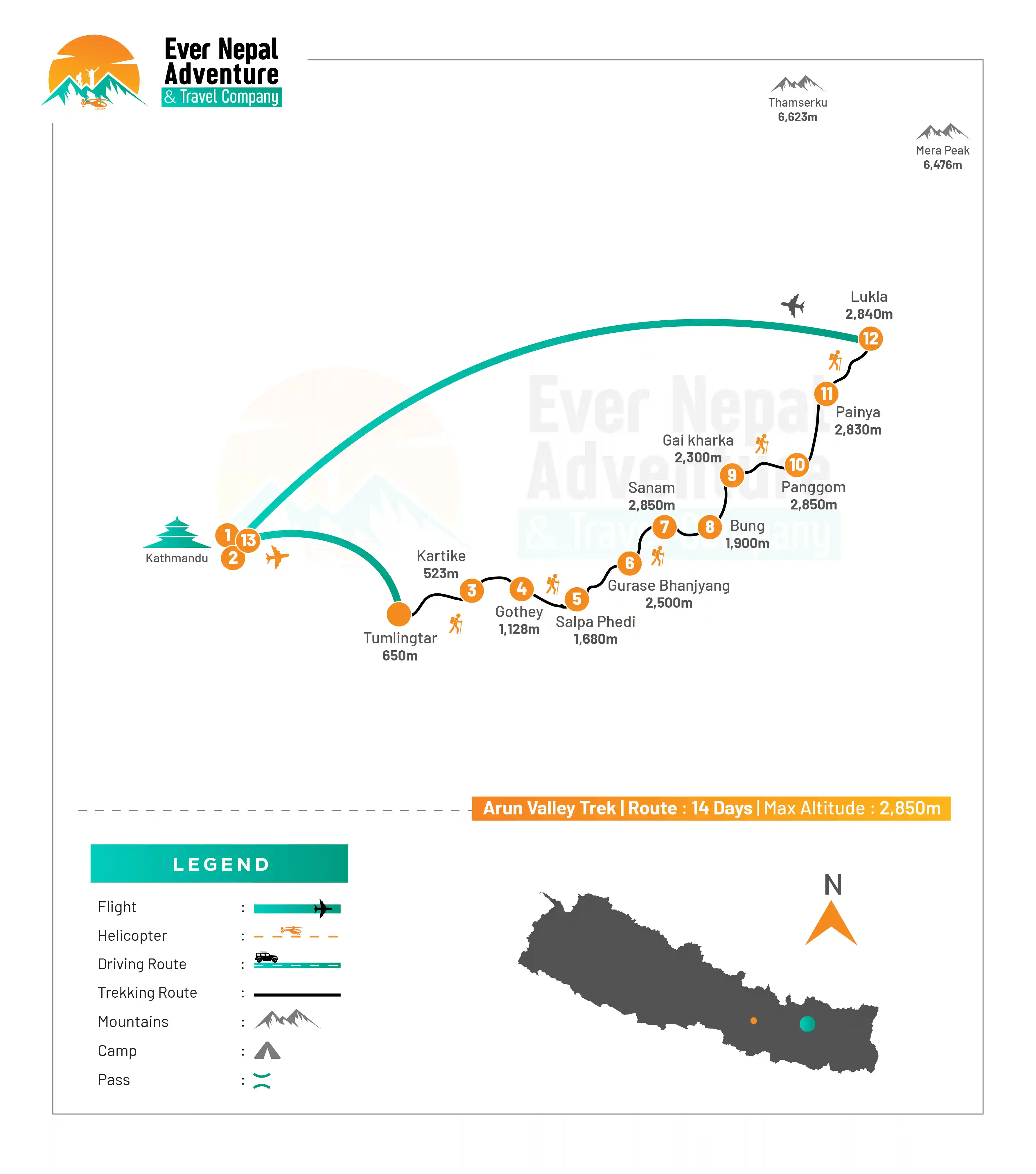
Arun Valley Trek route map

What's included

  • Airport pick-up and drop-off in Kathmandu
  • 2 nights hotel accommodation in Kathmandu (3-star category) with breakfast
  • Domestic flights (Kathmandu ↔ Tumlingtar and Lukla ↔ Kathmandu)
  • All required trekking permits and TIMS card
  • Full board meals (breakfast, lunch, and dinner) during the trekking period
  • Tea house/lodge accommodation during the trek
  • Experienced licensed trekking guide throughout the journey
  • Porters for luggage transportation (as per group size and route requirement)
  • All ground transportation as per the itinerary
  • First aid medical kit carried by the guide
  • Government taxes and official service charges
  • Farewell dinner in Kathmandu after trek completion

What's excluded

  • International airfare to and from Nepal
  • Nepal entry visa fee (available on arrival at the airport)
  • Travel insurance (must include trekking and emergency evacuation coverage)
  • Personal trekking gear and clothing (boots, jackets, sleeping bag, etc.)
  • Meals in Kathmandu other than breakfast
  • Hot showers, Wi-Fi, charging, and personal expenses during trekking
  • Alcoholic beverages, bottled drinks, snacks, and extra food items
  • Tips for guide, porter, and staff (customary but not mandatory)
  • Emergency rescue or evacuation costs, if required
  • Any additional nights in Kathmandu due to early arrival, delay, or weather changes
  • Any services not mentioned in the "Cost Included" section.

Packing List for Arun Valley Trek

The Arun Valley Trek passes through the remote eastern region of Nepal between the Makalu Barun National Park and Everest region. The trail goes through low warm valleys, deep forests and high mountain passes, which can range from hot to cold in just one day. Layering clothing and essential trekking equipment is crucial; for safety, comfort, and a smooth trekking experience.

Head

  • Warm woolen beanie
  • Buff or neck gaiter
  • UV-protection sunglasses
  • Climbing sunglasses 
  • Lightweight headlamp with extra batteries
  • Sun hat or cap
  • High-SPF sunscreen
  • Lip protection cream
  • Face moisturizer
  • Personal hygiene wipes

Hands

  • Lightweight inner gloves
  • Waterproof outer gloves
  • Heavy insulated summit gloves
  • Hand warmers (optional)

Upper Body

  • Thermal base layers 
  • Lightweight trekking t-shirts
  • Long-sleeved trekking shirts
  • Fleece jacket
  • Waterproof shell jacket
  • Windproof outer layer
  • Insulated summit jacket
  • Lightweight puffy jacket

Lower Body

  • Thermal inner pants
  • Trekking trousers
  • Waterproof shell pants
  • Insulated climbing pants
  • Comfortable camp pants
  • Fleece lined pants

Footwear

  • Waterproof hiking boots
  • Peak climbing boots.
  • Flip-flops or sandals for outdoor wear
  • Gaiters
  • Woolen trekking socks
  • Liner socks
  • Summit push boots
  • Climbing Equipment
  • Climbing harness
  • Ice axe
  • Crampons

Ascend and descend Equipments

  • Locking carabiners
  • Helmet
  • Safety ropes and slings
  • Trekking poles

Climbing backpack

  • Duffel bag
  • Toiletries
  • Toothbrush and toothpaste
  • Biodegradable soap
  • Quick-dry towel
  • Toilet paper
  • Hand sanitizer
  • Small shampoo bottle
  • Wet wipes
  • Nail clipper
  • A moisturizer and cold cream

Accessories

  • Water bottles
  • Water purification tablet or Filter
  • Power bank
  • Universal travel adapter
  • Portable Solar Charger (Optional)
  • Camera or mobile phone
  • Snacks and energy bars
  • Notebook or journal

First Aid Kit

  • Diamox
  • Personal prescription medicines
  • Pain relievers
  • Medical tape and bandages.
  • Blister treatment kit
  • Antiseptic cream and wipes
  • Anti-diarrheal medicine
  • Oral rehydration salts
  • Oral/parenteral medications for cough and cold symptoms

Specific Gears for Women

There are items that women trekkers might want, as they are in remote terrains with limited facilities during the trek. These additional gears for women enhance their comfort while not adding much weight to the backpack. Some of these essential items for women for Arun Valley Trek include: 

  • Sports bras
  • Thermal leggings
  • Comfortable undergarments
  • Sanitary pads or tampons
  • Personal skincare products
  • Moisturizing lotion
  • Lip care products
  • Travel-size hygiene products
  • Fleece headband
  • Hair ties and clips

Document Requirement

Proper documentation is required for permits and safety checks of the Arun Valley Trek, which is an area for restricted feelings in eastern Nepal.

  • Valid Passport: All international trekking participants should have a passport valid for six months or more. It is necessary for permits and for ID verification at trekking checkpoints.
  • Nepal Visa: Any foreign visitors desiring to trek in Nepal must get a valid tourist visa; before or at their arrival. This visa permits entry and travel to trekking areas which also include Arun Valley.
  • Trekking Permits (TIMS & Conservation Area Permits): Trekkers need to have TIMS and area conservation permits; for the protected area such as Makalu Barun National Park. These permits play a role in ensuring safety and conserving the environment; during the trekking.
  • Passport-Sized Photos: Have 2 to 4 passport sized photographs for permit registration and trekking documentation.
  • Travel Insurance: Highly recommended and it should cover treatment, evacuation and high altitude trekking, as the area of Arun Valley itself is quite remote.

Frequently Asked Questions

How difficult is the Arun Valley Trek?

Depending on the route, the Arun Valley trek is a moderate or challenging trek. It features longer walking times, high climb areas and not as well served sections. The hike is much easier and more enjoyable with good fitness and previous hiking experience.

How many hours do we walk daily on this trek?

On an average, hikers walk around 5 to 7 hours a day. Certain areas may be more challenging, as can weather, and to avoid fatigue during extended trekking days, pacing and rest breaks are important.

What is the best time for Arun Valley Trek?

The optimum time for observation is spring (March to May) and autumn (September to November). Despite the cool autumn temperatures and the muddy conditions in some areas, it is a good time to trek in these months as the weather is stable, the view on the mountains is clear and the trekking temperature is good.

Is altitude sickness a problem in Arun Valley Trek?

Yes, there is a possibility of getting altitude sickness in high areas above 3,000 meters. Symptoms include headache, dizziness and fatigue, and to minimize risk, walkers should acclimatize, walk at their own pace, and stay well-hydrated.

Is this trek suitable for beginners?

This trek is an opportunity for beginners with good fitness levels to complete it, but there are some recommendations for preparation. Walking practice and stamina training is helpful; as there are long and distant walking sections along the trail.

Are tea houses available on the route?

Yes, basic tea houses are present in most villages but facilities are basic. Staying overnight may be difficult in the deep wilderness, don't forget to pack simple sleeping quarters and food.

What kind of food is available during the trek?

The main foods are dal bhat, noodles, rice, vegetables, potatoes, and tea. In lower areas there will be more variety, but in higher regions, the choice is less rich and specific

Do we need a guide for Arun Valley Trek?

A guide is strongly suggested as it can be rather remote and less marked. Navigation, safety and permissions along the journey are provided with a guide, as well as communication with the locals.

Is mobile network available during the trek?

Mobile signal lacks in the higher and more remote parts but is available in lower sections. There is limited Internet connectivity during most of the trek.

Why is Arun Valley Trek special?

The hike is acclaimed for its pristine nature, few crowds, as well as high biodiversity from Everest regions to Makalu regions. It provides a tranquil hiking way-off the beaten path.

User Review