Kanchenjunga Base Camp Circuit Trek - 24 Days

Tour Info

trip code

DE-0039

Starting Point/ End Point

Kathmandu

Accommodations

Lodge/ Tea House

Max Altitude

5143m

Duration

24 days

country

Nepal

Trip grade

Challenging

Activities

Trekking

Best Season

March, April, May, September, October, November

Overview

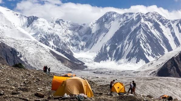
The Kanchenjunga Base Camp Trek is one of the most beautiful and challenging journeys in the far eastern region of Nepal. This route takes you to Kanchenjunga North Base Camp (5,143 m) and brings you very close to Kanchenjunga South Base Camp (4,610 m), where you can enjoy clear views of the mountains and glaciers. Mount Kanchenjunga, the world’s third-highest peak, lies on the border between Nepal and Sikkim. By trekking here, you can enjoy peaceful Himalayan valleys and explore both the southern and northern base camps. The Kanchenjunga Conservation Area is rich in wildlife, with endangered species like the snow leopard, red panda, and Himalayan black bear. You get to enjoy views from Kanchenjunga South Base Camp at Ramche (4,580 m). After South Base Camp, you can also visit Oktang Viewpoint (4,730 m), and get views of the south face of Mount Kanchenjunga and the long Yalung Glacier from here.  This trek combines natural beauty, wildlife, culture, and challenging terrain.

Details

The Kanchenjunga Circuit Trek is one of the most beautiful and rewarding treks in eastern Nepal. You should consider the Kanchenjunga Circuit Trek if you want to explore one of Nepal’s most remote and untouched regions. You get the closest views of mountains like Tent Peak, Mt. Janu, and Mt. Kambachen from here. As you trek, you will pass through the Kanchenjunga Conservation Area, a protected region filled with forests, rivers, pastures, and glaciers. You will also enjoy panoramic views of several eight-thousanders, including Mt. Everest, Mt. Makalu, and Mt. Lhotse. 

There is a chance that you spot rare wildlife such as red pandas, snow leopards, musk deer, and Himalayan black bears. The area is also home to nearly 2,000 species of flowering plants, including varieties unique to Nepal, and hundreds of birds and other animals. By visiting the South Base Camp at Ramche and the North Base Camp at Pang Pema, you can enjoy mountain and glacier views. You can also trek to viewpoints like Oktang to watch the south face of Kanchenjunga.

Highlights

  • Trek to the base camp of Mt. Kanchenjunga, the third-highest mountain in the world.

  • Walk through the Kanchenjunga Conservation Area, which is home to many rare plants and animals.

  • If you are lucky, you may spot wildlife like the snow leopard, Bengal tiger, red panda, Himalayan black bear, and different birds.

  • Walk through remote villages and see the daily lifestyle, culture, and traditions of the local people.

  • Reach the Kanchenjunga South Base Camp and experience close-up views of this huge mountain.

  • Cross high passes such as Mirgin La, Sinion La, Sele La, and Sinelapche Bhanjyang.

  • Enjoy wonderful mountain scenery, glaciers, and wide Himalayan views throughout the trek.

Itinerary

Day 1: Arrival in Kathmandu

You arrive in Kathmandu, the capital city of Nepal, and be welcomed by our representative at the airport. After the check-in process at your hotel, you can take some rest after a long flight or wander around the lively streets of Kathmandu, exploring places like Thamel, Durbar Marg, and Ason Bazaar. In the evening, enjoy a warm dinner and prepare for the trek starting the next day.
Max Elevation: 1,400 meters (Kathmandu)
Travel Distance: 6 to 8 kilometers
Travel Hours: 20 to 30 minutes
Accommodation: 3 star standard Hotel
Meal: Dinner

Day 2: Guided Full Day Tour

You visit some important cultural and historical places in Kathmandu. This day covers important places like Swayambhu Stupa, Patan Palace, Boudha Stupa, Pashupati Temple, Kathmandu Durbar Square, and Bhaktapur Durbar Square.

A. Swayambhu Stupa:
Swayambhu Stupa, also called the Monkey Temple, is one of the oldest and most sacred Buddhist stupas in Nepal. You see the large dome, prayer wheels, and colorful flags while enjoying views of the city from the hilltop.

B. Patan Palace:
Patan Palace, located in the city of Patan, is famous for its traditional Newari architecture and historic courtyards. Here, you explore the museum and see ancient art, sculptures, and cultural artifacts.

C. Boudha Stupa:
Boudha Stupa is one of the largest Buddhist stupas in Nepal. It is a peaceful place where you walk around the stupa, spin the prayer wheels, and see many monks and pilgrims.

D. Pashupati Temple:
Pashupati Temple is a major Hindu temple dedicated to Lord Shiva. You get to observe daily rituals, see the holy Bagmati River, and learn about local religious traditions.

E. Kathmandu Durbar Square:
Kathmandu Durbar Square is a historic area in the heart of the city. You see ancient palaces, temples, and statues, and experience the lively local life and traditional architecture.

F. Bhaktapur Durbar Square:
Bhaktapur Durbar Square is known for its well-preserved medieval buildings and pagoda-style temples. You can walk around the square, visit local shops, and enjoy the traditional Newari culture.
Max Elevation: 1,400 meters (Kathmandu city)
Travel Distance: 40 to 50 kilometers (total driving distance for the full-day tour)
Travel Hours: 6 to 7 hours
Accommodation: 3 star standard Hotel
Meal: Dinner

Day 3: Fly from Kathmandu to Bhadrapur and Drive to Taplejung

From Tribhuvan International Airport in Kathmandu, you take a short flight to Bhadrapur, it takes about 30 to 35 minutes. And from Bhadrapur, you drive around 8 to 9 hours to cover 241 kilometers to Taplejung in a shared Jeep, passing tea plantations, small villages, and forests along the Mechi Highway. Once you reach Taplejung, you see farms, rivers, pastures, and glaciers there. You can also visit the famous Pathibhara Devi Temple, a well-known religious place located on Taplejung Hill.

Flight Duration: 35 minutes
Max Elevation: 1,500 meters (Taplejung)
Travel Distance: 241 kilometers (flight and drive)
Travel Hours: 8 to 9 hours (including flight and drive)
Accommodation: Tea house/Lodge
Meal: Breakfast, Lunch, and Dinner

Day 4: Trek from Taplejung to Lalikharka

The trek moves forward from Taplejung to the village of Lalikharka, and to cover about 8 km and it takes you around 3 to 4 hours. Lalikharka is a peaceful village that offers basic tea house accommodations and a chance to experience local life in this remote region. On the way, you pass through small villages, terraced fields, and forested areas with rhododendrons and bamboo. You enjoy views of the surrounding hills and mountains as you settle in for the night at Lalikharka.

Max Elevation: 2,050 meters (between Taplejung and Lalikharka)
Travel Distance: 8 kilometers
Travel Hours: 3 to 4 hours
Accommodation: Tea house/Lodge
Meal: Breakfast, Lunch, and Dinner

Day 5: Trek from Lalikharka to Kheswa

Your trekking route leads you to Kheswa from Lalikharka, which takes you around 5 to 6 hours to complete. The trail goes through dense forests, and you see terraced fields and small villages along the way. You notice the local people working in their farms and get a glimpse of traditional life in this remote area. Kheswa is a quiet village where you stay overnight in a tea house or lodge, enjoy simple meals, and rest before continuing your trek the next day.

  • Max Elevation: 2,380 meters (between Lalikharka and Kheswa)

  • Travel Distance: 9 to 10 kilometers 

  • Travel Hours: 5 to 6 hours

  • Accommodation: Tea house/Lodge

  • Meal: Breakfast, Lunch, and Dinner


Day 6: Trek from Kheswa to Mamankhe

By continuing to trek toward Mamankhe from Kheswa, you have to trek around 5 to 6 hours. As you trek toward Mamankhe from Kheswa, you pass through several small villages. The people in this region mainly follow Hindu and Kirati traditions, and you notice small shrines and prayer flags. Along the way, you cross small rivers and streams that flow down from the surrounding hills. Reaching Mamankhe, you find simple tea houses for overnight stay and have a chance to experience the local culture, observe traditional houses, and interact with friendly villagers.

Max Elevation: 1,950 meters (between Chisapani and Mamankhe, the highest point)
Travel Distance: 12 kilometers
Travel Hours: 5 to 6 hours
Accommodation: Tea house/Lodge
Meal: Breakfast, Lunch, and Dinner

Day 7: Trek from Mamankhe to Yamphudin

To reach Yamphudin from Mamankhe, you have to trek around 4 to 5 hours. Yamphudin is a village in the Kanchenjunga region, known for its traditional Kirati culture and warm local hospitality. On the way from Mamankhe to Yamphudin, you cross the Tamor River and some smaller rivers flowing from the nearby hills. Along the route, you enjoy views of the surrounding Himalayan peaks, including Mt. Pandim and Mt. Kabru. After you reach Yamphudin, you find simple tea houses for overnight stay and enjoy the views of the nearby mountains and valleys.

Max Elevation: 2,300 meters (Tinjure, the highest point between Mamankhe and Yamphudin)
Travel Distance: 10 kilometres
Travel Hours: 4 to 5 hours
Accommodation: Tea house/Lodge
Meal: Breakfast, Lunch, and Dinner

Day 8: Trek from Yamphudin to Tortong

From Yamphudin, it takes you around 7 to 8 hours to reach Tortong. Tortong is a small village in the Kanchenjunga region, known for its traditional Kirati and Hindu culture. On the way from Yamphudin, you cross small streams and parts of the Tamor River, which flows down from the surrounding mountains. You can observe the clear views of Himalayan peaks such as Mt. Pandim, Mt. Kabru, and nearby ridges.
Max Elevation: 2,900 meters (Phurte, the highest point between Yamphudin and Tortong)

Travel Distance: 15 kilometers 
Travel Hours: 7 to 8 hours
Accommodation: Tea house/Lodge
Meal: Breakfast, Lunch, and Dinner

Day 9: Trek from Tortong to Cheram

You have to trek around 3 to 4 hours to reach Cheram from Tortong. Cheram is a small village in the Kanchenjunga region, known for its peaceful atmosphere and traditional culture. On the way to Cheram, you pass through remote villages where people follow Kirati and Hindu customs. You will cross streams that flow into the Tamor River, and along the way. Also, you can enjoy views of Himalayan peaks like Mt. Pandim and Mt. Kabru.

Max Elevation: 3,100 meters (Rokpa, the highest point between Tortong and Cheram)
Travel Distance: 8 kilometers
Travel Hours: 3 to 4 hours
Accommodation: Tea house/Lodge
Meal: Breakfast, Lunch, and Dinner

Day 10: Acclimatization Day in Cheram

Acclimatization day in Cheram is very important to help your body adjust to the higher altitude. You can take short treks around the village and nearby areas, visit local houses, and see how people live in this high mountain region. From here, you can also enjoy clear views of nearby Himalayan peaks, including Mt. Pandim and Mt. Kabru.

Max Elevation: 3,200 meters (Cheram, the village itself, highest point in the immediate area)
Travel Distance: 3 to 5 km (optional short hikes around the village for acclimatization)
Travel Hours: 1 to 2 hours (depending on the pace and chosen trails)
Accommodation: Tea house/Lodge
Meal: Breakfast, Lunch, and Dinner


Day 11: Trek from Cheram to Ramchaur (Ramche)

You trek from Cheram to Ramche, which takes you about 3 to 4 hours. Along the way, you will enjoy views of the Yalung Glacier and the surrounding mountains. If conditions allow, you can take a short hike to Oktang for even better views. From Ramche, you can get the closest view of Kanchenjunga South Base Camp on this trek. After exploring the area, you return to Cheram for the night.

Max Elevation: 3,450 meters (Ramche, the highest point between Cheram and Ramche)
Travel Distance: 8 to 9 kilometers
Travel Hours: 3 to 4 hours
Accommodation: Tea house/Lodge
Meal: Breakfast, Lunch, and Dinner

Day 12: Trek from Ramche to Yanlung Base Camp and Back to Cheram

To reach Yanlung Base Camp from Ramche and to get back to Cheram, it takes you around 4 to 5 hours. You start your walk from Ramche toward Yalung Base Camp, following the open valley that slowly leads you closer to the Yalung Glacier. The trail continues toward the glacier area, where you can see the Yalung River flowing below and the wide ice walls of Mt. Kanchenjunga rising in front of you. From this point, the views of Mt. Kabru and Rathong Peak also become clearer. After spending some time exploring the base camp area, you get back to Cheram for the night, ending the day with views of the surrounding mountains.

Max Elevation: 3,650 meters (Yanlung Base Camp, the highest point on the round trip from Ramche to Yanlung Base Camp and back)
Travel Distance: 10 km (round trip)
Travel Hours: 4 to 5 hours
Accommodation: Tea house/Lodge
Meal: Breakfast, Lunch, and Dinner

Day 13: Trek from Cheram to Sele La

You leave Cheram and begin your gradual climb toward Sele La Pass, which sits at an altitude of around 4,290 meters. As you move higher, you pass a few small yak grazing spots used seasonally by locals. The trail continues toward a long ridge where the views begin to open, you can see the peaks of the Kanchenjunga range. You can also walk near the Simbuwa River valley, which remains visible for a good portion of the climb. The trek also leads you to the base of Sele La, where the quiet surroundings and mountain landscape create a peaceful atmosphere.

Max Elevation: 4,290 meters (Sele La Pass, the highest point between Cheram and Sele La)
Travel Distance: 12 kilometers
Travel Hours: 6 to 7 hours
Accommodation: Tea house/Lodge
Meal: Breakfast, Lunch, and Dinner

Day 14: Trek from Sele La to Ghunsa

To reach Ghunsa from Sele La, you have to trek around 6 to 7 hours. Ghunsa is located at around 3,475 meters, and the people here in the village are influenced by Tibetan Buddhist culture. As you move higher, you pass small settlements where people follow ancient traditions, offering prayer flags and spinning prayer wheels as part of their daily life. By moving along the banks of the river, you can also catch views of peaks like Jannu from afar.

Max Elevation: 3,700 meters (Lhonak, the highest point between Sele La and Ghunsa)
Travel Distance: 14 kilometers
Travel Hours: 6 to 7 hours
Accommodation: Tea house/Lodge
Meal: Breakfast, Lunch, and Dinner

Day 15 : Trek from Ghunsa to Kambachen

As you continue your trek, you have to trek around 6 to 7 hours to reach Kambachen from Ghunsa. You start seeing the Jannu Glacier and other snowy peaks shining ahead. Along the way, you cross a small bridge and reach a grassy area called Rhambuk Kharka. Some parts of this section are known for loose rocks and old landslides, so you walk gently and carefully. After crossing a steep ridge, the trail opens into a wide valley with beautiful views of Phole Peak, Sobithonge, and Jannu Himal. After a long trek through these rocky sections, the trail slowly moves down to Kambachen, a place surrounded by high mountains.

Max Elevation: 3,850 meters (Rhambuk Kharka, the highest point between Ghunsa and Kambachen)
Travel Distance: 13 kilometers
Travel Hours: 6 to 7 hours
Accommodation: Tea house/Lodge
Meal: Breakfast, Lunch, and Dinner

Day 16: Trek from Kambachen to Lhonak

To reach Lhok from Kambachen, you have to trek around 5 to 6 hours. Lhonak is located at an altitude of 4,780 meters, and the area feels wide and open with a peaceful Himalayan atmosphere. On the way, you pass small seasonal settlements where people follow Tibetan Buddhist culture, marked by prayer stones and quiet rituals. You trek along the Ghunsa Khola, which later merges into the larger flow connected to the Kanchenjunga Glacier. As you move higher, you get the clear views of Mera Peak, Nepal Peak, and the Twin Peak.

Max Elevation: 4,780 meters (Lhonak, the highest point between Kambachen and Lhonak)
Travel Distance: 12 kilometers
Travel Hours: 5 to 6 hours
Accommodation: Tea house/Lodge
Meal: Breakfast, Lunch, and Dinner

Day 17: Trek from Lhonak to Kanchenjunga Base Camp and Overnight at Pang pema

After breakfast, you begin your trek from Lhonak toward Pang Pema. As you move forward, the Lhonak Glacier comes into view, and the surrounding snow-covered peaks become more impressive. Reaching Pang Pema at around 5,100 meters, you can see Kanchenjunga, Yalung Kang, Wedge Peak, and Nepal Peak clearly. The area is quiet and peaceful, giving you time to admire the glaciers and mountains. After exploring the base camp, you spend the night at Pang Pema, surrounded by stunning high-altitude views.

Max Elevation: 5,100 meters (Pang Pema, the highest point between Lhonak and Kanchenjunga Base Camp)
Travel Distance: 10 kilometers
Travel Hours: 5 to 6 hours
Accommodation: Tea house/Lodge
Meal: Breakfast, Lunch, and Dinner

Day 18: Trek from Pang Pema to Lhonak

Pang Pema sits at around 5,100 meters, surrounded by high snow-covered peaks and glaciers. Today, you will trek about 10 km back toward Lhonak, which is at 4,780 meters, taking around 3 to 4 hours. Along the way, you pass small seasonal settlements where people follow Tibetan Buddhist traditions, with prayer stones and small shrines. You will also walk near the Ghunsa and Lhonak streams, enjoying clear views of Kanchenjunga North, Yalung Kang, and Twin Peak. The calm open valley makes the walk peaceful as you reach Lhonak for the night.

Max Elevation: 5,100 meters (Pang Pema, the highest point on the return trek to Lhonak)
Travel Distance: 10 kilometers
Travel Hours: 3 to 4 hours
Accommodation: Tea house/Lodge
Meal: Breakfast, Lunch, and Dinner

Day 19: Trek from Lhonak to Ghunsa

You start your trek from Lhonak at around 4,780 meters and head down toward Ghunsa, which sits at 3,475 meters, which takes you around 6 to 7 hours. You pass through small seasonal settlements where locals follow Tibetan Buddhist traditions and maintain prayer stones along the way. On the route, you also cross the Ghunsa River and enjoy open views of snow-covered peaks such as Kanchenjunga North, Jannu, and Twin Peak. 

Max Elevation: 4,780 meters (Lhonak, the highest point between Lhonak and Ghunsa)
Travel Distance: 14 kilometers
Travel Hours: 6 to 7 hours
Accommodation: Tea house/Lodge
Meal: Breakfast, Lunch, and Dinner

Day 20: Trek from Ghunsa to Amjilosa

You leave Ghunsa at 3,475 meters and move toward Amjilosa, which is located at around 2,308 meters. Along the way, you pass small settlements where locals follow Tibetan Buddhist and Kirati cultural traditions, often marked by prayer flags and small shrines. After crossing the Ghunsa River, you get the clear views of peaks such as Kanchenjunga, Jannu, and nearby ridges.

Max Elevation: 3,475 meters (Ghunsa, the highest point between Ghunsa and Amjilosa)
Travel Distance: 16 kilometers
Travel Hours: 6 to 7 hours
Accommodation: Tea house/Lodge
Meal: Breakfast, Lunch, and Dinner

Day 21: Trek from Amjilosa to Chirwa

The trek takes you about 6 to 7 hours to reach Chirwa from Amjilosa. You trek from Amjilosa at about 2,308 meters down to Chirwa, which sits at approximately 1,270 meters. Along the way, you pass small villages where people follow Tibetan Buddhist and Kirati traditions, marked by prayer stones and small shrines. You also cross the Amjilosa River and other smaller streams while enjoying clear views of distant peaks from the Kanchenjunga range.

Max Elevation: 2,308 meters (Amjilosa, the highest point between Amjilosa and Chirwa)
Travel Distance: 18 kilometers
Travel Hours: 6 to 7 hours
Accommodation: Tea house/Lodge
Meal: Breakfast, Lunch, and Dinner

Day 22: Drive to Taplejung via Mitlung

To reach Taplejung via Mitlung from, you have to take a drive covering a distance of around km in about 7 to 8 hours. The route passes through small villages where locals follow Tibetan Buddhist and Kirati traditions, and you can notice prayer flags and small shrines along the way. You cross rivers and streams flowing from the surrounding mountains, enjoying the open valley views. As you reach Taplejung, you can observe local village life and spend the night here.

Max Elevation: 2,560 meters (Taplejung, the highest point along the drive from Mitlung to Taplejung)
Travel Distance: 120 kilometers
Travel Hours: 6 to 7 hours
Accommodation: Tea house/Lodge
Meal: Breakfast, Lunch, and Dinner

Day 23: Drive to Bhadrapur

You continue your drive towards Bhadrapur from Taplejung, passing through Deurali. It is the junction of the Pathibhara Temple pilgrimage site and the Kanchenjunga Circuit trail. Along the way, you will see small villages where locals follow Tibetan Buddhist and Kirati traditions, and enjoy open views of the surrounding hills and rivers. Upon arrival in Bhadrapur, you will check in to your hotel and rest after the long journey.

Max Elevation: 300 meters (Bhadrapur, the highest point along the drive from Taplejung to Bhadrapur)
Travel Distance: 180 kilometers
Travel Hours: 7 to 8 hours
Accommodation: Tea house/Lodge
Meal: Breakfast, Lunch, and Dinner

Day 24: Fly to Kathmandu

Take a flight from Bhadrapur to Kathmandu, which lasts about 35 minutes, giving you a final view of the Himalayan mountains. On arrival in Kathmandu, you can check in to your hotel and rest for the day. If you have time, you can stroll around the city and explore some local areas. In the evening, you celebrate the successful completion of the Kanchenjunga Circuit Trek at a nearby restaurant, enjoying a relaxing end to your adventure.

Flight Duration: 35 minutes
Max Elevation: 1,400 meters (Kathmandu, the highest point on arrival from Bhadrapur flight)
Travel Distance: 220 km (flight distance from Bhadrapur to Kathmandu)
Travel Hours: 35 minutes
Accommodation: 3 or 4 Star Hotel
Meal: Breakfast and Lunch

What's included

  • Stay in 3 star hotel in Kathmandu with B/B plan

  • All accommodations in lodges/tea houses during the treks

  • All standard meals (breakfast, lunch and dinner) during the trek

  • All necessary paper works, Conservation entry permits

  • An experienced professional english speaking Guide

  • Salary, Food, Drinks, Accommodation, Transportation and Insurance for the

Guide and Porter

  • Welcome and Farewell dinner in Kathmandu in a typical Nepali restaurant with

a cultural dance performance in the evening

  • Medical kit (carried by your trek leader)

  • Rescue operation arrangement in case of emergency conditions (funded by

travel insurance)

  • All necessary paperwork and trekking permits (National Park Permit, TIMS)

  • First Aid Kit (carried by your trek leader)

  • All government taxes and official expenses

  • Guaranteed Departures

  • Lifetime Deposit

  • No Booking Fee

  • Hot drinks (tea and coffee 3 times in day)

  • Purified drinking water

What's excluded

  • International airfare

  • Nepal entry visa; you can obtain a visa easily upon your arrival at Tribhuvan International Airport in Kathmandu

  • Travel insurance (if there is emergency)

  • Lunch and Dinner while you are in Kathmandu and Pokhara

  • Beverage (cold drinks and hard drinks

  • Wifi, Battery charges, hot shower

  • Your personal expenses

  • City sightseeing and entrance fees (See sightseeing and entrance fees)

  • Tips for the guide, porter & driver (Tipping is Expected)

  • Items and transportation are not included and mentioned in itinerary

Packing List For Kanchenjunga Base Camp Trek

The Kanchenjunga Circuit is a long-duration trek through a remote wilderness where supplies are limited. You will experience everything from hot, humid lowlands to freezing, high-altitude glacial environments. This packing list focuses on durability and high-performance layers to keep you safe over the course of 24 days.

  • Head

    • Fleece or wool beanie for high altitudes

    • Sun hat with neck coverage for long days in the sun

    • UV-rated glacier sunglasses (with side shields if possible)

    • High-quality headlamp with multiple sets of spare batteries

    • Warm neck gaiter or buff

  • Hands

    • Lightweight fleece gloves

    • Heavy-duty waterproof insulated mittens or gloves

  • Upper Body

    • Long-sleeved and short-sleeved moisture-wicking base layers (3-4 sets)

    • Mid-weight fleece or wool sweater

    • High-loft down jacket (suitable for -20°C)

    • Hard-shell waterproof and windproof jacket

    • Lightweight windbreaker for lower elevations

  • Lower Body

    • Convertible trekking trousers

    • Heavyweight thermal leggings

    • Waterproof shell trousers

    • Casual clothes for teahouses and travel days

  • Footwear

    • Stiff-soled, waterproof trekking boots (essential for rough moraine)

    • Light sneakers or crocs for camp use

    • Thick wool trekking socks (6 pairs)

    • Thin liner socks (to prevent friction)

  • Toiletries

    • Sunscreen (SPF 50+) and zinc for nose/lips

    • Biodegradable soap, shampoo, and wet wipes

    • Large supply of hand sanitizer

    • Personal hygiene kit including nail clippers (24 days is long!)

    • Toilet paper (4-5 rolls)

  • Accessories

    • 60-80L Duffel bag (for porters) and 35L daypack

    • Heavy-duty trekking poles

    • 4-Season sleeping bag (provided or personal)

    • Water bottles or bladder (3L total capacity)

    • High-capacity power bank and solar charger (highly recommended)

  • First Aid Kit

    • Full course of Diamox for altitude

    • Antibiotics for chest and gut infections

    • Blister treatment kit (moleskin, athletic tape)

    • Personal prescription medications

  • Miscellaneous Items

    • Water purification system (filter and tablets)

    • Earplugs for noisy teahouses

    • Travel journal and pens

    • Small repair kit (sewing kit, duct tape)

  • Specific Gears for Women

While on the trek, there are certain essentials that women must carry in order to complete the journey successfully. Having these gears ensures comfort, hygiene, and protection throughout the trek in changing weather and altitude conditions.

  • Moisture-wicking sports bras

  • Menstrual cup or sufficient biodegradable pads/tampons

  • Small bottle of dry shampoo

  • Trowel and waste bags for remote sections

Documents Required

The Kanchenjunga region is a restricted area near the sensitive borders of India and China. Strict permit regulations are enforced, and you must travel with a registered agency and a licensed guide. Ensuring all your paperwork is in order before leaving Kathmandu is critical.

  • Kanchenjunga Restricted Area Permit (RAP): This permit is required to enter the restricted zones of the Taplejung district and can be obtained from the Department of Immigration, Kathmandu (must be through an agency). It can cost around $20 USD per person per week for the first four weeks.

  • Kanchenjunga Conservation Area Project (KCAP) Permit: It is to support local conservation and environmental management. It can be obtained via Kathmandu or Taplejung. The cost is around 2,000 NPR.

  • TIMS (Trekkers' Information Management System) Card: This is for the purpose of registration for safety and data tracking in the mountains. This card is obtained through your trekking agency. It can cost you around 2,000 NPR.

  • Passport: Must be valid for 6 months beyond the trip. Carry 4 photocopies.

  • Passport Photos: Carry at least 8 photos; they are needed for multiple permits and local connectivity.

  • Travel Insurance: Mandatory. Must cover high-altitude trekking (up to 5,500m) and emergency helicopter rescue.


Frequently Asked Questions

How physically demanding is the Kanchenjunga Circuit?

This is perhaps the most strenuous trekking journey that can be undertaken in Nepal. It takes 24 days to complete, with altitudes in excess of 5,100 meters, as well as trekking through rocky moraine terrains and traversing high altitude passes.

Can I trek Kanchenjunga solo?

It’s not possible for you to trek to Kanchenjunga alone. This trekking route doesn’t allow solo trekking. You have to travel in a group comprising two or more people.

What is the accommodation like in this remote region?

While teahouses have improved, they are more basic than those in Everest or Annapurna. Expect simple wooden rooms, communal dining areas, and very basic squat toilets. In some spots, facilities are seasonal and very limited.

How is the food variety on this trek?

Most meals will consist of traditional Dal Bhat. As the region is remote, the variety of "Western" food is much lower than in other regions. It is fresh, organic, and perfect for keeping your energy up.

Is there electricity and WiFi available?

Electricity is very limited and mostly solar-powered. You can charge devices in some villages for a fee, but a solar charger is recommended. WiFi is rare and often unreliable; do not count on having internet for most of the trip.

What is the risk of altitude sickness?

The risk is very high due to the prolonged period of time and the highest elevation reached. We will have acclimatization days along with a gradual increase in elevation during our trekking route, which will lower the risk of altitude sickness.

When is the best time to do the Kanchenjunga Circuit?

The ideal time for having clear skies is between October and November. Another good season would be from March to May, when you can witness the blooming of rhododendrons.

Are there many shops to buy gear or snacks?

Once you leave Taplejung, there are very few shops. You should bring all your essential gear, snacks (like energy bars and nuts), and medications from Kathmandu.

Is the water safe to drink?

You should never drink untreated tap or stream water. Use a high-quality water filter or purification tablets. Boiled water can also be purchased at teahouses.

What happens in an emergency?

In case of any emergency, your guide will take help from the agency operating out of Kathmandu for helicopter evacuation. That is why it is necessary to have an insurance policy that covers helicopter evacuation at altitude.

User Review