Barun Valley Trek For 23 Days

Tour Info

trip code

EN-036

Starting Point/ End Point

Kathmandu

Accommodations

Lodge/ Tea House

Max Altitude

5000m

Duration

23 days

country

Nepal

Trip grade

Easy

Activities

Trekking

Best Season

March, May, September, November

Overview

The Barun Valley Trek is a notable journey into the central area of the Makalu Barun National Park in the Sankhuwasabha District. This trek takes you toward the base of Mt. Makalu, the fifth-highest mountain in the world. It offers an opportunity to explore one of the most untouched wilderness areas in the Himalayas. The trek showcases a clear change in landscapes, from lush tropical forests and terraced fields at lower altitudes to the snow-covered landscapes of high-altitude glaciers. 

You travel through traditional villages such as Tashi Gaon and Num, and experience the hospitality of the Rai and Sherpa communities. The trekking route is dotted with important points such as crossing Kauma Danda at 3,500 meters, enjoying the views at Nehe Kharka at 3,750 meters, and finally arriving at the Makalu Base Camp at 5,000 meters. From the Barun Valley, you are treated to staggering views of Makalu, Chamlang, Lhotse, and Everest.

Details about Barun Valley Trek

An important journey that takes place in the Sankhuwasabha District of Makalu Barun National Park is the Barun Valley Trek. This trek is located in the middle region of the park, and you can visit the Barun Valley to experience a remote area that remains far away from the busier tourist trails. This region is famous for its rich biodiversity and is home to some of the rarest plants and animals in the world. As you trek, you will also notice how these people live in close proximity to such a harsh environment while maintaining their traditional heritage. There are mani walls, colored prayer flags, and small monasteries along your trek, reflecting their strong spiritual connection to these mountains. Visiting Barun Valley provides an understanding of a way of life that has remained unchanged for centuries.

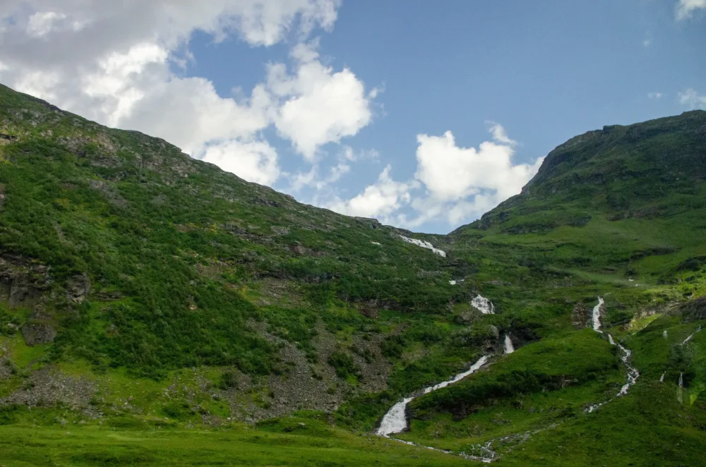
The beauty of the Barun Valley is unlike anything else in Nepal. Deep gorges, towering waterfalls, and high-altitude meadows covered in wildflowers in the spring are just some of the natural beauties to be found here. This is a good place for wildlife enthusiasts who get to see rare species such as the red panda, Himalayan black bear, and many species of colorful pheasants. The combination of challenging mountain passes and green valleys makes this trek an experience for those who enjoy both.

The Barun Valley Trek stands out from other treks in Nepal because it offers a quiet and remote environment. Also, you can enjoy the natural beauty of the Himalayas, listen to the sounds of the Barun River, and feel a close connection to nature. This trek is a combination of high-altitude adventure and cultural discovery in one of the most remote corners of Nepal.
Highlights

  • Get clear, close-up views of Mt. Makalu (8,485m), the fifth-highest peak, along with Lhotse, Everest, and Baruntse.

  • Cross the high ridges of Kauma Danda (3,500m), offering a wide view of the surrounding mountain ranges.

  • Discover the isolated Barun Valley, known for its unusual rock formations, massive waterfalls, and hanging glaciers. 

  • Visit traditional Rai and Sherpa villages like Tashi Gaon to get a sense of the local way of life. 

  • Reach the Makalu Base Camp at 5,000 m for a high-altitude adventure amidst impressive peaks. 

  • Trek through the Makalu Barun National Park, home to rare flora and fauna, including the red panda.

  • Experience a mix of teahouse stays and clean camping areas in the central wilderness area.

Itinerary

Day 01: Arrival in Kathmandu

Once you arrive in Kathmandu, which is the capital of Nepal, you will be received by a representative who will be awaiting you at the airport. After completing the formalities of checking into the hotel, you can either relax after the exhausting journey or go out for a stroll around the vibrant streets of Kathmandu, visiting areas like Thamel, Durbar Marg, Ason Bazaar, etc. The evening will be spent setting up food and getting ready for the upcoming expedition, which will start in a few days.

  • Max Elevation: 1,400 meters (Kathmandu)
  • Travel Distance: 6 to 8 kilometers
  • Travel Hours: 20 to 30 minutes
  • Accommodation: 3 Star Standard Hotel
  • Meal: Dinner

Day 02: Guided Full Day Tour & Trek Preparation

After breakfast, you’ll head out at 08:00 AM in a private jeep to explore the heart of Kathmandu. This isn't just a tour; it’s an introduction to the culture you’ll see reflected in the mountains. You will visit the sacred Hindu grounds of Pashupatinath, the massive Buddhist stupa at Boudhanath, and the hilltop Swayambhunath (Monkey Temple) for a view of the entire valley. Your guide will be there to share the history and stories behind each site.

The afternoon is all about getting ready for the trail. You'll meet with your trekking team for a formal briefing on the Barun Valley’s specific conditions. We will double-check your gear, making sure your boots and layers are up to the task, and finalize the last of the paperwork. It’s a great time to ask any lingering questions before we head to the airport tomorrow morning.

  • Max Elevation: 1,450 meters (Swayambhu Stupa)
  • Travel Distance: 25 to 30 kilometers
  • Travel Hours: 6 to 7 hours
  • Accommodation: 3 Star Standard Hotel
  • Meal: Breakfast

Day 03: Fly to Tumlingtar (518m) & Drive to Chichira (1,980m)

You take a domestic flight from Kathmandu to the hilltop airstrip at Tumlingtar. Upon landing, the remaining crew members are assembled, and a drive begins to Chichira. The route passes through villages and forest areas, rising from the warmer lowlands. Chichira is a small village and offers, on good days, the first glimpse of the high mountains. On a clear night, the beautiful, irregular shapes of Mt. Makalu and the other peaks in the area can be seen for the first time.

  • Max Elevation: 1,980 meters (Chichira)
  • Travel Distance: 35 to 40 kilometers (Drive)
  • Travel Hours: 5 to 6 hours (Flight + Drive)
  • Accommodation: Tea house/Lodge
  • Meals: Breakfast, Lunch, and Dinner

Day 04: Trek from Chichira to Num (1,560m)

The trek starts with a walk through rhododendron and oak forests. Then it moves along a ridgeline, passing through some small hamlets and farming settlements. There is a small descent as you move towards Num, which is a village on a ridgeline with a view of the Arun River. The region is full of lush vegetation, with a subtropical environment that gives a good introduction to the trekking part of the journey.

  • Max Elevation: 1,980 meters (Chichira)
  • Travel Distance: 12 to 14 kilometers
  • Travel Hours: 6 to 7 hours
  • Accommodation: Tea house/Lodge
  • Meals: Breakfast, Lunch, and Dinner

Day 05: Trek from Num to Seduwa (1,500m)

Today's trek starts with a pretty steep descent through the woods and open fields until you reach the Arun River. Once you've crossed the suspension bridge, the path heads right back up the other side of the valley, climbing steeply toward Seduwa. This village is a key stop on the route because it's where they check everyone's permits. It’s a great spot to catch a glimpse of daily life here, like watching the local farmers tending to their terraced rice and millet fields.

  • Max Elevation: 1,560 meters (Num)
  • Travel Distance: 10 to 12 kilometers
  • Travel Hours: 5 to 6 hours
  • Accommodation: Tea house/Lodge
  • Meals: Breakfast, Lunch, and Dinner

Day 06: Trek from Seduwa to Tashi Gaon (2,100m)

The trail climbs gently through the countryside, passing through small mani walls and prayer flags. Tashi Gaon is the last permanent settlement in the valley. It is a beautiful Sherpa village surrounded by mountains. As you reach higher, the temperature decreases, and the vegetation starts to change from subtropical to temperate forest. The village serves as a vital cultural hub where you can witness the resilient mountain lifestyle of the Sherpa people before heading into the uninhabited wilderness that lies ahead.

  • Max Elevation: 2,100 meters (Tashi Gaon)
  • Travel Distance: 10 to 11 kilometers
  • Travel Hours: 5 to 6 hours
  • Accommodation: Tea house/Lodge
  • Meals: Breakfast, Lunch, and Dinner

Day 07: Trek from Tashi Gaon to Kahuma Danda (3,500m)

This is a bit challenging day as the trail climbs steeply upward. You leave the farmland behind and enter dense forests of rhododendron and oak. As you reach the ridge at Kahuma Danda, the trees become smaller, and the views become visible. From the top, you can see wide views of the surrounding peaks as you adjust to the higher altitude. This steep ascent marks your true entry into the high-altitude wilderness, where the air begins to thin and the landscape shifts toward the rugged alpine zone.

  • Max Elevation: 3,500 meters (Kahuma Danda)
  • Travel Distance: 8 to 10 kilometers
  • Travel Hours: 6 to 7 hours
  • Accommodation: Tea house/Lodge/Tent
  • Meals: Breakfast, Lunch, and Dinner

Day 08: Rest day at Kahuma Danda (3,500m)

You will stay at Kahuma Danda today to let your body get used to the high altitude. This is important for your safety. While it is a rest day, you can go for short walks along the ridge. From the ridge, you can see Mt. Makalu and Kanchenjunga if the weather is clear. This day helps you prepare physically for the higher parts of the Barun Valley that you will reach tomorrow.

  • Max Elevation: 3,500 meters (Kahuma Danda)
  • Accommodation: Tea house/Lodge/Tent
  • Meals: Breakfast, Lunch, and Dinner

Day 09: Trek from Kauma to Mumbuk (3,570m)

The trail continues along the ridge, crossing several small passes including the Tutu La and Shipton La. Along the way,the trail is rocky and can be covered in snow depending on the season. After reaching the highest point of the ridge, the trail descends through a forest of fir and rhododendron toward Mumbuk, a quiet camping area in the forest.

  • Max Elevation: 4,200 meters (Shipton La Pass)
  • Travel Distance: 9 to 11 kilometers
  • Travel Hours: 5 to 6 hours
  • Accommodation: Tea house/Lodge/Tent
  • Meals: Breakfast, Lunch, and Dinner

Day 10: Trek Mumbuk to Nehe Kharka (3,750m)

Today, you descend into the Barun River valley. The path is steep and rocky at first, leading down to the riverbed. Once in the valley, the trail levels out and follows the river through alpine grassland and forests. Nehe Kharka is a high-altitude grazing area where you can often see yaks. The steep valley sides rise above on both sides.

  • Max Elevation: 3,750 meters (Nehe Kharka)
  • Travel Distance: 12 to 14 kilometers
  • Travel Hours: 6 to 7 hours
  • Accommodation: Tea house/Lodge/Tent
  • Meals: Breakfast, Lunch, and Dinner

Day 11: Trek from Nehe Kharka to Sherson (4,600m)

The trail today follows the Barun River, and goes up slowly as the valley gets wider. You will cross several small streams and walk through high fields. Near Sherson, the trees stop growing. The ground is covered with small bushes and rocks. You are now in a high-altitude area. From here, you can see the face of Mt. Makalu in front of you.

  • Max Elevation: 4,600 meters (Sherson)
  • Travel Distance: 10 to 12 kilometers
  • Travel Hours: 5 to 6 hours
  • Accommodation: Tea house/Lodge/Tent
  • Meals: Breakfast, Lunch, and Dinner

Day 12: Trek from Sherson to Makalu Base Camp (5,000m)

You walk along a rocky path next to the glacier. The climb is steady and you must breathe carefully because of the height. When you arrive at Makalu Base Camp, you are in an area of ice and rock. The south face of Mt. Makalu is directly above you. This is the highest part of the trek.

  • Max Elevation: 5,000 meters (Makalu Base Camp)
  • Travel Distance: 7 to 9 kilometers
  • Travel Hours: 5 to 6 hours
  • Accommodation: Tea house/Lodge/Tent
  • Meals: Breakfast, Lunch, and Dinner

Day 13: Explore Makalu Base Camp (4,870m)

You spend the day exploring the base camp area and the surrounding glaciers. You can hike up to nearby viewpoints to see the Everest East Face (Khangshung Face) and Lhotse. It is a day to take photos, observe the surroundings of the high mountains, and observe the large size of the Barun glacier. For an even deeper adventure, you can hike toward the pristine Barun Pokhari, a sacred glacial lake that sits at the very foot of the mountain's massive ice walls.

  • Max Elevation: 5,000 meters (Makalu Base Camp)
  • Travel Distance: 4 to 6 kilometers (Exploration)
  • Travel Hours: 3 to 4 hours
  • Accommodation: Tea house/Lodge/Tent
  • Meals: Breakfast, Lunch, and Dinner

Day 14: Trek from Makalu Base Camp to Nhe Kharka (3,000m)

You begin the walk back by going down through the Barun Valley. You can walk faster today because you are moving to a lower altitude. The landscape becomes greener as you go down. You will return to Nhe Kharka, where the air has more oxygen and is easier to breathe. This makes the walking feel less difficult than in the higher areas.

  • Max Elevation: 5,000 meters (Makalu Base Camp)
  • Travel Distance: 15 to 17 kilometers
  • Travel Hours: 5 to 6 hours
  • Accommodation: Tea house/Lodge/Tent
  • Meals: Breakfast, Lunch, and Dinner

Day 15: Trek from Nhe Kharka to Mumbuk (3,570m)

After breakfast, you start the day by following the river downstream before beginning a steady climb that leads us back toward the tree line. The landscape changes from rocks to forest. When you reach the camp at Mumbuk, there are trees and plants all around you. This part of the trek is different from the rocky ground at the base camp.

  • Max Elevation: 3,750 meters (Nhe Kharka)
  • Travel Distance: 10 to 12 kilometers
  • Travel Hours: 5 to 6 hours
  • Accommodation: Tea house/Lodge/Tent
  • Meals: Breakfast, Lunch, and Dinner

Day 16: Trek from Mumbuk to Kauma (3,470m)

Today, you walk back over the Shipton La and Tutu La passes. Even though you have been here before, the view looks different from this direction. You can see the Barun Valley behind you as you climb. The trail leads back to the ridge at Kauma. You can rest here after finishing the walk over the high passes. Reaching the ridge at Kauma provides a well-earned sense of accomplishment, as you have successfully navigated the most challenging high-altitude passes of the entire expedition.

  • Max Elevation: 4,200 meters (Shipton La)
  • Travel Distance: 9 to 11 kilometers
  • Travel Hours: 5 to 6 hours
  • Accommodation: Tea house/Lodge/Tent
  • Meals: Breakfast, Lunch, and Dinner

Day 17: Trek from Kauma to Tashi Gaon (2,070m)

The trail goes down from the ridge. It is long and steep with many turns. You will enter the rhododendron forest again. As the altitude gets lower, the air is easier to breathe. You will arrive at the village of Tashi Gaon. You can eat a meal at a local lodge. This is the end of the high-altitude part of the trek. From here, walking is easier.

  • Max Elevation: 3,470 meters (Kauma)
  • Travel Distance: 10 to 12 kilometers
  • Travel Hours: 5 to 6 hours
  • Accommodation: Tea house/Lodge
  • Meals: Breakfast, Lunch, and Dinner

Day 18: Trek from Tashi Gaon to Balung (760m)

The path descends further through farming communities and forests. You move into much warmer, tropical air as you approach the lower valley. Balung is a small village where you can see the lifestyle of the local Rai people and enjoy the lush greenery of the lower Arun Valley. This long descent serves as a transition from the rugged alpine environment back into the fertile, humid river basin.

  • Max Elevation: 2,070 meters (Tashi Gaon)
  • Travel Distance: 12 to 14 kilometers
  • Travel Hours: 5 to 6 hours
  • Accommodation: Tea house/Lodge/Tent
  • Meals: Breakfast, Lunch, and Dinner

Day 19: Trek from Balung to Pukuwa (1,520m)

The trail after Balung goes through the valley and crosses small streams, where you will pass several villages with farm fields and fruit trees. Then the path goes up slightly toward Pukuwa through forests and farms. The walking pace is steady and easier than the previous days at high altitude. The trail remains well-defined as it navigates the transition between the riverbank and the higher forest slopes.

  • Max Elevation: 1,520 meters (Pukuwa)
  • Travel Distance: 10 to 12 kilometers
  • Travel Hours: 5 to 6 hours
  • Accommodation: Tea house/Lodge/Tent
  • Meals: Breakfast, Lunch, and Dinner

Day 20: Trek from Pukuwa to Bumling (370m)

The trail leads you further down into the river valley. Temperatures are higher because the altitude is lower. You walk through the farm fields and the bamboo. The village of Bumling is located next to the river. You can get a view of how the local people utilize the river and the fields for their work. This is a shorter walking day towards the end of the trek.

  • Max Elevation: 1,520 meters (Pukuwa)
  • Travel Distance: 14 to 16 kilometers
  • Travel Hours: 6 to 7 hours
  • Accommodation: Tea house/Lodge/Tent
  • Meals: Breakfast, Lunch, and Dinner

Day 21: Trek from Bumling to Tumlingtar (460m)

This is the last day of your walking itinerary. On this day, you will walk along the Arun River in the morning, and then there is one final climb to the town of Tumlingtar. When you arrive at Tumlingtar, you will have finished the walking portion of your journey. The rest of the day is then free time at the lodge, relaxing, and looking forward to flying home the next day.

  • Max Elevation: 460 meters (Tumlingtar)
  • Travel Distance: 12 to 14 kilometers
  • Travel Hours: 5 to 6 hours
  • Accommodation: Tea house/Lodge
  • Meals: Breakfast, Lunch, and Dinner

Day 22: Flight from Tumlingtar to Kathmandu

Your flight to Kathmandu leaves in the morning. When you land, you will be picked up to go to the hotel. The rest of the day can be spent relaxing at the hotel or spending the day in Thamel to get some shopping done. In the evening, a farewell dinner will be held.

  • Max Elevation: 1,400 meters (Kathmandu)
  • Travel Distance: 510 kilometers (Flight)
  • Travel Hours: 45 to 50 minutes (Flight)
  • Accommodation: 3 Star Standard Hotel
  • Meal: Breakfast and Dinner

Day 23: Departure from Kathmandu

It’s officially time to head home. On your final day, our representative will pick you up and drive you to Tribhuvan International Airport in time for your departure. As you head to the gate, you will leave with memories of the Barun Valley and Mt. Makalu. Standard procedures for international departure will be followed to ensure you reach your gate in time for your return flight.

  • Max Elevation: 1,400 meters (Kathmandu)
  • Travel Distance: 6 to 8 kilometers
  • Travel Hours: 20 to 30 minutes
  • Accommodation: N/A
  • Meal: Breakfast

Notes:

If you finish the trek early because of illness or other problems, there are no refunds for flights, hotels, rooms, or food already paid for. You must also pay for your own hotel and food for any extra days you stay in Kathmandu.

Trek Route

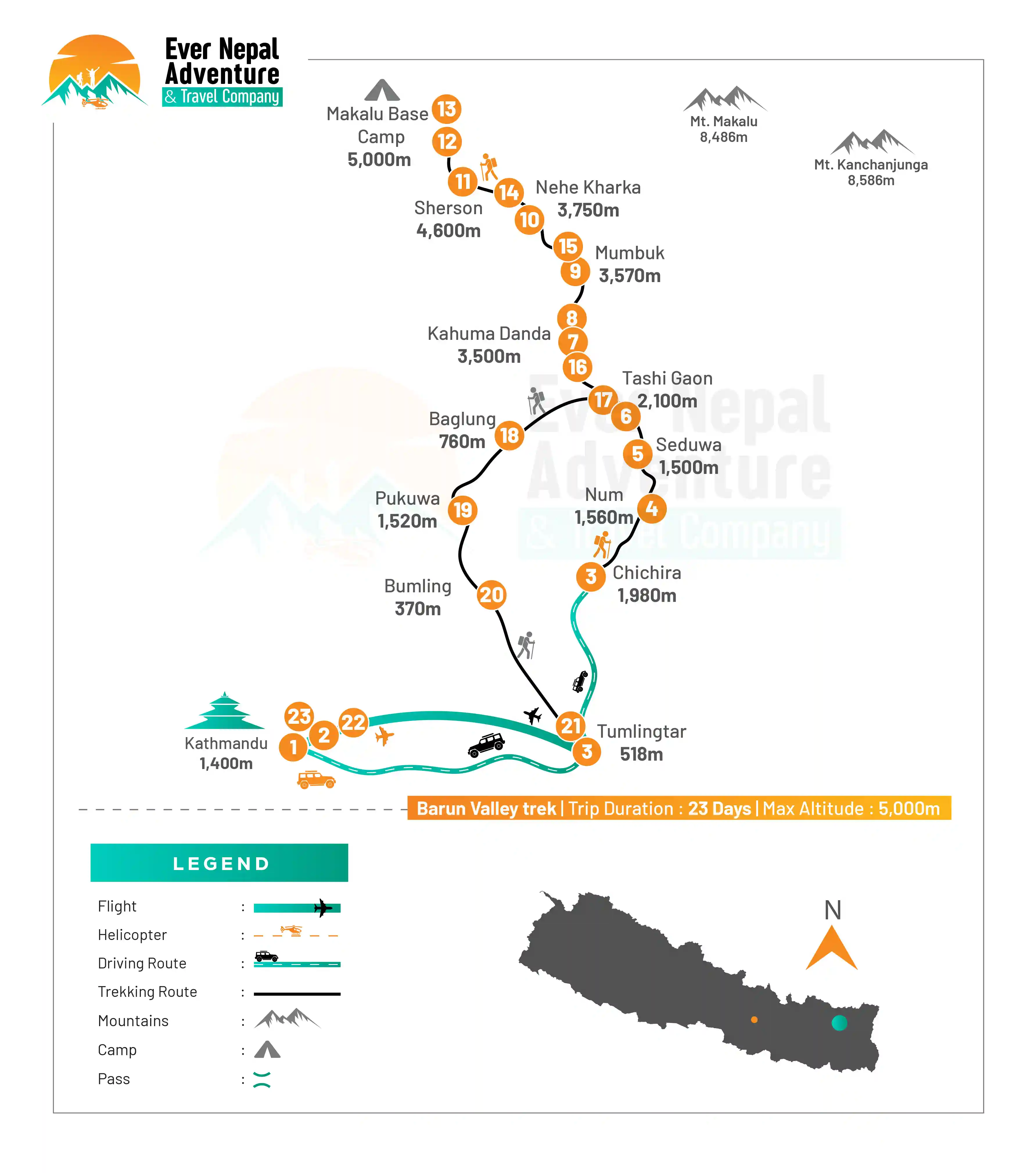
Barun Valley Trek 23 Days Route

Packing List for Barun valley trek

The Barun Valley trek is a journey through pristine forests, glacier valleys, steep hiking paths and high-altitude scenery in the heart of the beautiful Makalu Barun National Park. The weather is variable here, so it's important to take the necessary clothing to keep warm, dry and comfortable during your trip. Having a well-balanced packing list can also help you walk a lot easier over long days out on the trail.

Headwear and Face Protection

  • Hats, sun cap, or trekking hat
  • Beanie hat
  • Loose scarf, buff, or neck piece
  • UV-protected sunglasses
  • The clothing and accessories with high SPF
  • Use sun and lip moisturizer
  • Lightweight headlamp with additional lights
  • Face towel or wet wipes

Clothing for Upper Body

  • Thermal inner layers
  • Breathable trekking t-shirts
  • Full-sleeve hiking shirts
  • Warm fleece jacket
  • Insulated down jacket
  • Waterproof shell jacket
  • Windproof outer layer
  • Lightweight rain poncho

Clothing for Lower Body

  • Trekking trousers
  • base layers or thermal leggings
  • Waterproof hiking pants
  • Comfortable camp pants
  • Fast-drying shorts or pants

Hand Protection

  • Warm fleece gloves
  • Waterproof outer gloves
  • Lightweight liner gloves

Trekking Footwear

  • Waterproof trekking boot
  • Camp sandals or slippers
  • Woolen hiking socks
  • Quick-dry inner socks
  • Gaiter for muddy and snowy sections

Personal Toiletries

  • Toothbrush and toothpaste
  • Small soap or body wash
  • Hand sanitizer
  • Disposable towels (tissue paper and wet wipes)
  • Quick-drying towel
  • Shampoo sachets
  • Nail clipper
  • Dry skin moisturizer

Trekking Equipment

  • Trekking poles
  • Sleeping bag
  • Duffel bag
  • Day backpack with rain cover
  • Reusable water bottles
  • Water Filter Tablets or Water filter
  • Dry bags or zipper lock bags
  • Light weight crampons (where necessary, in snowy months)

Medical and First Aid Supplies

  • Diamox for altitude sickness
  • Basic pain relief medicines
  • Band-aids and blister pads
  • Antiseptic cream
  • Personal medicines
  • Anti-diarrheal tablets
  • ORS packets
  • Medication for cold and cough

Electronics and Extra Items

  • Cell phone or camera
  • Power bank
  • Charging cables
  • Universal adapter
  • Notebook or journal
  • Snacks and energy bars
  • Binoculars

Essential Gear for Female Trekkers

For female trekkers, there are a few additional items that can be useful for the trek, particularly due to the location of the tea house in the Barun Valley area.

  • Sanitary pads or tampons
  • Intimate hygiene wipes
  • Moisturizing cream and sunscreen
  • Hair tie or a fleece headband
  • Warm Leggings for evenings
  • Personal skincare essentials

Documents

There are a few important permits and personal documents that must be obtained prior to commencing Barun Valley Trek. Always take both a printed and electronic copy with you on the trip.

  • Makalu Barun National Park Entry Permit: It is necessary to obtain an entry permit for the protected area of Makalu and Barun Valley area. It will be picked up from Nepal Tourism Board office, in Kathmandu. The permit is paid at an estimated cost of NPR 3000 for foreign nationals and less for SAARC nationals.
  • TIMS Card (Trekkers’ Information Management System): The TIMS card enables authorities to keep track of trekkers for safety and emergency reasons. It is a document that is needed before entering the trekking region both by independent trekkers and by guided groups.
  • Valid Passport: You should have a 6 months or more valid passport on arrival in Nepal. Passport copies are typically required on issuance of a permit and on domestic flight, for trekkers.
  • Passport-Sized Photographs: Carry 3 to 4 recent passport size photos. They are much in demand for permits and emergency documents.
  • Nepal Visa: Tourists must obtain a valid Nepal visa upon arrival in Kathmandu or before submitting an application in Kathmandu. Service fee shall depend on the duration of stay for the visa.
  • Travel Insurance: It is highly advisable for the Barun Valley Trek to have a good travel insurance policy. This will cover high altitude trackings, medical treatment, rescue by helicopter at altitudes above 4000 meters.


What's included

  • Airport pick up and transfer by private car/jeep.

  • Standard twin-sharing hotel in Kathmandu for three nights, including breakfast.

  • All trek meals (breakfast, lunch, and dinner) during the trek.

  • Fresh fruit every evening after dinner during the trek.

  • Trekking lodge (Tea House) and tent camp accommodation.

  • Full camping equipment (two-man tent, kitchen tent, toilet tent, etc.).

  • All trekking permits (Sagarmatha National Park and Makalu Barun Conservation Area).

  • Kathmandu Valley sightseeing by private car/jeep.

  • Kathmandu-Tumlingtar-Kathmandu flights and domestic airport taxes.

  • Certified English-speaking trekking guide and experienced porters.

  • An oxygen meter for health monitoring and a comprehensive first aid kit.

  • T-shirt and trip success certificate from Sherpa Expedition and Trekking.

What's excluded

  • Meals in Kathmandu (lunch and dinner).

  • Nepal entry visa fees ($30 for 15 days, $50 for 30 days).

  • Personal travel and medical insurance.

  • International airfare.

  • Personal expenses (laundry, phone calls, alcoholic and non-alcoholic drinks).

  • Desserts, sweet items, and snacks during the trek.

  • Fees for hot showers and battery charging at tea houses.

  • Tips for the guide, porter, and driver (tipping is expected)

  • Entrance fees for Kathmandu sightseeing monuments ($30 per person).

  • Excess baggage of more than 15 kg for the Tumlingtar flight.

Frequently Asked Questions

How difficult is the Barun Valley Trek?

The Barun Valley Trek is moderately difficult or challenging due to hard trails, steep ascents and long days of hiking. Traditional walkers tend to go through more remote places where facilities are limited, and if you have walked the trail before and know how, it will be a lot easier and more pleasant to do in good physical shape.

What is the best season for the Barun Valley Trek?

The best time to take this hike; is during the spring (March to May) or fall (September to November). It's safer to hike the trails, the skies are clearer, and mountain views are superb in these months. Rhododendron forests bloom in the valley in spring too.

Do I need a guide for the Barun Valley Trek?

It is advisable to have a guide so as to be sure of not getting lost in the remote areas where there are few signs and communication facilities. A guide is also used to navigate, interact with people in the surrounding area, manage accommodation, and deal with emergencies in harsh conditions on the trail or during bad weather.

Is altitude sickness common in Barun Valley Trek?

After reaching an altitude of more than 3000 meters, trekkers can develop altitude sickness. Symptoms can be headache, nausea and tiredness. The best way to avoid serious problems from the altitude during the trek is to do it properly; walk slowly, drink plenty of water, and stay away from alcohol.

Are tea houses available on the Barun Valley Trek route?

In some villages, basic tea houses and homestays will be found but the facilities are far simpler than popular routes on the Everest or Annapurna routes. Camping may also be required in some remote areas for the itinerary and type of trek.

How long does the Barun Valley Trek usually take?

This hike is typically of 12 to 18 days, depending on the route length and acclimatization period, as well as side trips within the itinerary. Some trekkers take it in conjunction with the Makalu Base Camp route for a longer and a more adventurous trekking experience.

Is internet or mobile network available during the trek?

In a few lower villages, mobile networks are available, but weak or non-existent in the higher and more remote parts of the valley. There are very few internet facilities so please inform family members beforehand that they may not be able to communicate with you during the trek.

What kind of food is available during the trek?

There are basic foods available at most tea houses like dal bhat (a combination of vegetables, rice, meat, and curds), noodles, fried rice, soup, potatoes, eggs, and tea. As you ascend further out in the backcountry, you can find fewer choices for your food, but hot food is available pretty much all along the trail.

Can beginners do the Barun Valley Trek?

Beginners with good fitness and preparation can complete the trek, but it is more suitable for trekkers who already have some high-altitude hiking experience. The remote nature, basic facilities, and longer walking hours can feel challenging for first-time trekkers.

How cold does it get in the Barun Valley region?

Temperatures vary by season and altitude. Nights can drop below freezing, especially in higher camps and during late autumn or winter. Carrying warm layers, insulated jackets, gloves, and a proper sleeping bag is important for staying comfortable in cold conditions.

User Review