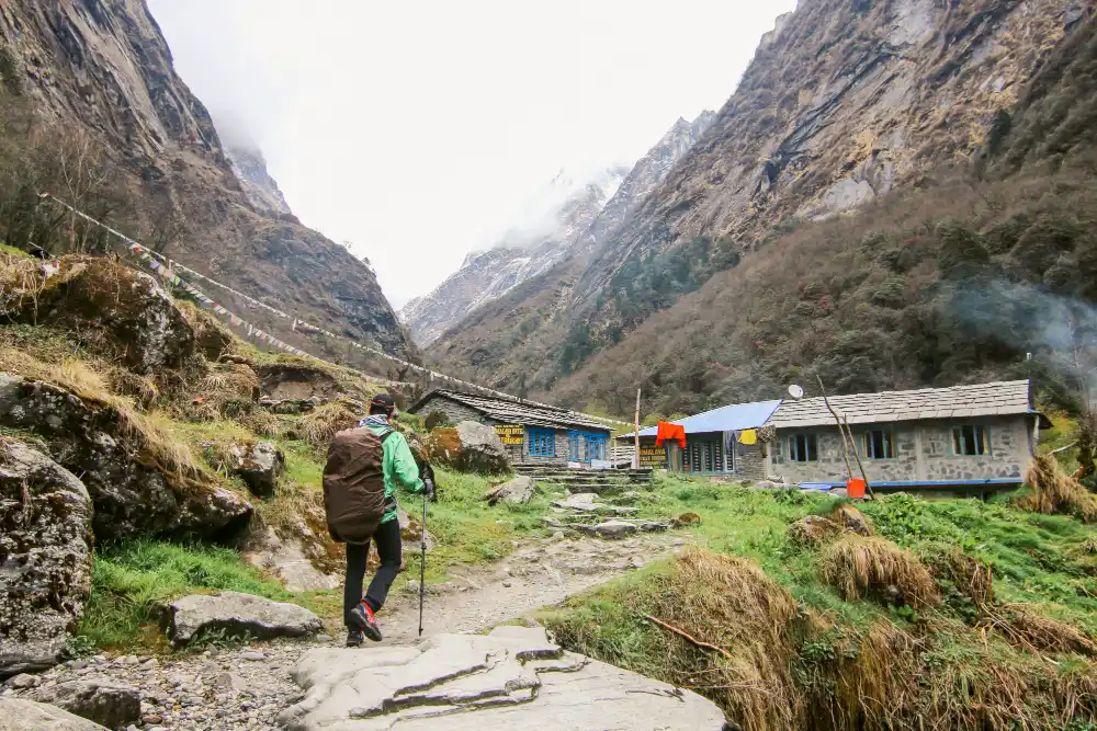
Tsum Valley- Manaslu circuit Trek for 21 Days

Tour Info

trip code

EN-022

Starting Point/ End Point

Kathmandu

Accommodations

Lodge/ Tea House

Max Altitude

5106m (Larkya La Pass)

Duration

21 days

country

Nepal

Trip grade

Moderate

Activities

Trekking

Best Season

February, March, April, May, June, September, October, November and December

Overview

Tsum Valley is a quiet and remote valley in northern Nepal, lying between the Shear Khola and Budhi Gandaki rivers. It is surrounded by glaciers from Ganesh Himal and Sringi Himal, which make the valley very beautiful. The valley is home to rare wildlife, such as Himalayan Thar and Blue Sheep, and hunting is strictly prohibited. Tsum Valley also has historic monasteries like Rachen, Mu, and Lungdang Gompa, showing its strong Buddhist culture. Mt. Manaslu, the eighth-highest mountain in the world at 8,156 meters, rising above the valley. From Tsum Valley, the trail continues into the Manaslu region, which is famous for its mountains and culture. The Manaslu Circuit goes around Mt. Manaslu, the eighth-highest mountain in the world. Villages like Dharapani, Bihi, Namrung, and Lho are along the way. You can also get views of Manaslu, Himalchuli, Ngadi Chuli, Ganesh Himal, and Annapurna II, from viewpoints like Syala, Samagaun, Manaslu Base Camp, and Larkya La Pass.

Details

Tsum Valley and the Manaslu Circuit is the place where you can experience nature and culture closely. The area is quiet, remote, and not crowded, so you can enjoy peaceful trails. You can see beautiful landscapes with tall mountains, glaciers, rivers, and green forests. The valley has many wild animals, including Himalayan Thar, Blue Sheep, marmots, and rare birds. You can visit old monasteries and walk through villages where people still follow Buddhist and Tibetan traditions.

Along the Manaslu Circuit, you can reach viewpoints like Syala, Samagaun, Manaslu Base Camp, and Larkya La Pass. From there, you can see Manaslu, Himalchuli, Ngadi Chuli, Ganesh Himal, and Annapurna II. You can explore terraced fields, apple orchards, and stone houses in the villages. You can feel the calm and peaceful atmosphere all around, and take photos of glaciers, lakes, mountains, and wildlife. Visiting this region lets you enjoy nature, learn about local culture, and see some of Nepal’s most amazing mountains.
Highlights

  • Witness the wide and peaceful landscapes of the Tsum Valley.

  • Walk around the beautiful Mt. Manaslu (8,163m) on a scenic trekking route.

  • Visit the sacred Milarepa Piren Phu Cave, also known as the Pigeon Cave.

  • Explore important monasteries like Mu Gompa and Lungdang Gompa.

  • See Dephydonma and the oldest monastery in the valley, Rachen Gompa.

  • Reach the high point of the trek at Larkya La Pass (5,106m).

  • Enjoy many side trips such as Birendra Lake, Pungyen Monastery, Tibetan Border, Ganesh Himal North Base Camp, Manaslu Base Camp, Tserang Gompa, and Kal Tal.

  • Experience clear views of glaciers, mountain peaks, lakes, and rocky landscapes.

  • Walk along parts of the old trading route that once connected Nepal and Tibet.

  • Trek on a peaceful and less-crowded trail throughout the journey.

Itinerary

Day 01: Arrival in Kathmandu (1,324m/4,344ft)

The first day of your journey begins with your arrival in Kathmandu, the capital of Nepal. You are picked up by our representative from Ever Nepal Adventure at Tribhuvan International Airport (TIA) and then driven to your booked hotel. Once you are at a hotel, you have some time to relax and unwind. Here, you can either choose to relax at the hotel or get exploring to visit some of the local alleys and lesser known cafes around your hotel. Following the brief relaxation or roaming session, you head back to your hotel in the evening where a small briefing session will be held. Following the briefing session, you head towards the dining hall for a welcome dinner where you shall be greeted by local Nepali cuisines and local cultural events. 

  • Max Elevation: 1,324 meters (4,344 feet)
  • Travel Distance: 5 to 6 kilometers
  • Travel Hours: 20 to 30 minutes
  • Accommodation: 3-star standard hotel 
  • Meal: Welcome dinner

Day 02: Full-Day Guided Sightseeing in Kathmandu

After breakfast, the sightseeing tour begins with a professional guide and a private vehicle. Throughout the day, you visit some of the most well-known heritage sites in Kathmandu. The guide explains the history, culture, and importance of each place you explore.

A. Swayambhunath Stupa (Monkey Temple)

Swayambhunath, also known as the Monkey Temple, is located on a hill above Kathmandu. The site is home to a large stupa and many monkeys. From here, you can enjoy calm views of the city and watch Buddhist prayers and people spinning prayer wheels.

B. Pashupatinath Temple

Pashupatinath is a sacred Hindu temple dedicated to Lord Shiva and is located along the Bagmati River. The temple features beautiful pagoda-style architecture with golden roofs and four main entrances. Visitors can observe rituals, prayers, and religious ceremonies held at the temple.

C. Bhaktapur Durbar Square

Bhaktapur Durbar Square was once the palace of ancient kings and is filled with temples, palaces, and stone statues. You explore important landmarks such as the 55-Window Palace, Nyatapole Temple, Golden Lion’s Gate, and Vatsala Temple. Walking through the square, you can see traditional Newari architecture and experience local culture.

D. Swayambhu Stupa / Monkey Temple:

Located on a small hill, Swayambhu offers a wide view of the Kathmandu Valley. It is also called the Monkey Temple because many monkeys live around the stupa. This site is very important to both Buddhists and Hindus.

  • Max Elevation: 1,450 meters (Swayambhunath Stupa)
  • Travel Distance: 25 to 30 kilometers (total driving distance)
  • Travel Time: 6 to 7 hours
  • Accommodation: 3-Star Hotel
  • Meal: Breakfast

Day 03: Drive to Machha Khola

After an early breakfast, you leave Kathmandu and begin a scenic drive towards  Machha Khola, which is the starting point of your trekking journey. On this journey, you follow the winding highways of Kathmandu valley and then descend towards the countryside of central Nepal. Along the way, you pass through many bustling towns, terraced farmlands, river valleys, and small settlements. The road follows the  Trishuli River, followed by the Gandaki River later in the journey. Alongside the rivers, you can also see the beautiful green hills, waterfalls and rural landscapes which accompany you throughout the journey. After you reach Arughat and Soti Khola, the road becomes a bit tougher and more adventurous, which offers you the first insight into the remote terrains in the Manaslu region. The drive continues through narrow mountain roads carved into steep hillsides before finally arriving at Machha Khola, a peaceful village situated beside the Budhi Gandaki River. Upon arrival, you check into a local teahouse, enjoy a warm meal, and rest for the night while preparing for the trek ahead.

  • Max Elevation: 1,200 meters (highest point along the driving route)
  • Travel Distance: 155 kilometer
  • Travel Hours: 7 to 8 hours
  • Accommodation: Tea House/Lodge
  • Meals: Breakfast, Lunch, and Dinner


Day 04: Trek from Machha khola to Jagat (1410m/4626ft)

You start the day with a simple breakfast around 7 AM and then begin walking toward Jagat. The trail follows the Budhi Gandaki River, and you cross a few suspension bridges on the way. After walking uphill for 3 to 4 hours, you reach Tattopani, where there is a small natural hot spring. From there, you keep trekking until you reach Jagat, a peaceful Gurung village with basic teahouses. The day takes about 6 to 7 hours and covers roughly 22.2 km.

  • Max Elevation: 1,410 meters (Jagat, the highest point between Machha Khola and Jagat)
  • Travel Distance: 22.2 kilometers
  • Travel Hours: 6 to 7 hours
  • Accommodation: Tea house/Lodge
  • Meals: Breakfast, Lunch, and Dinner

Day 05: Trek from Jagat to Lokpa (2040m/6692 ft)

Before you start your trek towards Lokpa, you can have breakfast in the morning. To reach Lokpa from Jagat, you need to cover about 17 km and which takes you around 5 to 6 hours. The trail first takes you to Salleri, where you can see the clear and stunning Shiring Himal. From there, you continue trekking for 2 to 3 hours to reach Philim, a larger village with farms, schools, and traditional stone houses. This is where the path to Tsum Valley splits, and you then continue on the trail until you arrive at Lokpa. 

  • Max Elevation: 2,040 meters (Lokpa, the highest point between Jagat and Lokpa)
  • Travel Distance: 17 kilometers
  • Travel Hours: 5 to 6 hours
  • Accommodation: Tea house/Lodge
  • Meals: Breakfast, Lunch, and Dinner

Day 06: Trek from Lokpa to Chumling (2386m/7828ft)

After breakfast at the lodge in Lokpa, you begin the trek deeper into the hidden Tsum Valley. The trail first descends through dense forests before reaching the Budhi Gandaki River. After crossing a suspension bridge, the route climbs steadily through pine and rhododendron forests while offering occasional views of Ganesh Himal. The peaceful trail passes small settlements and traditional farmland before reaching Chumling, one of the largest villages in the lower Tsum Valley. Chumling is known for its traditional Tibetan-influenced culture, stone houses, and beautiful monasteries. Upon arrival, you can explore the village and enjoy impressive views of the surrounding mountains before settling into your teahouse for the night.

  • Max Elevation: 2,386 meters (Chumling)
  • Travel Distance: 8.2 kilometers
  • Travel Hours: 5 to 6 hour
  • Accommodation: Tea House/Lodge
  • Meals: Breakfast, Lunch, and Dinner

Day 07: Trek from Chumling to Chhokang Paro (3031m/9944 ft)

Your day starts with a breakfast in Chumling before beginning the trek toward Chhokang Paro. The trail goes past Tanju’s water-powered prayer wheel and moves through pine forests before reaching Domje (2,460m). From Domje, you continue climbing toward Chhokang Paro, the largest village in Tsum Valley, where Lama culture is strong. Along the way, you can see terraced potato fields and get clear views of Buddha Himal and Siringi Himal. Chhokang Paro is also near a Tibetan market and a gateway to Geshe Lama Konchog’s retreat cave and Galdang Gumba. The day covers about 11 km and takes 4 to 5 hours.

  • Max Elevation: 3,031 meters (Chhokang Paro, the highest point between Chumling and Chhokang Paro)
  • Travel Distance: 11 kilometers
  • Travel Hours: 4 to 5 hours
  • Accommodation: Tea house/Lodge
  • Meals: Breakfast, Lunch, and Dinner

Day 08: Trek from Chhokang Paro to Nile (3361m/11026fts)

Following your morning meal at the lodge, the journey to the Nile continues with an easy and refreshing start. The journey to the Nile is about 11 km and takes most of the day, around 4 to 5 hours. The trail slowly goes uphill through small villages and fields with mountains around. You pass local farms and houses and see how people live in Tsum Valley. 

  • Max Elevation: 3,361 meters (Nile, the highest point between Chhokung Paro and Nile)
  • Travel Distance: 11 kilometers
  • Travel Hours: 4 to 5 hours
  • Accommodation: Tea house/Lodge
  • Meals: Breakfast, Lunch, and Dinner

Day 09: Acclimatization day and detour to Mugu Gompa (3700m/12139ft)

After breakfast, you start a trek toward Mu Gompa. Taking a rest day at higher elevation is an important part of safe trekking. Acclimatization day helps your body adjust to the higher altitude, which is important to avoid sickness. This trek from Nile to Mugu Gompa covers about 8 km and takes you around 3 to 4 hours. The trail first passes Rachen Gompa, the largest nunnery in Tsum Valley, where about 200 nuns live and follow their traditions. You then continue to the Nile, a small village known for its tasty potatoes and houses. After lunch at Chho Syong, the trail ascends steadily to Mu Gompa, a monastery for male monks. You can explore the area and the old monastery with its statues and artifacts. 

  • Max Elevation: 3,700 meters (Mugu Gompa, the highest point between Nile and Mugu Gompa)
  • Travel Distance: 8 kilometers
  • Travel Hours: 3 to 4 hours
  • Accommodation: Tea house/Lodge
  • Meals: Breakfast, Lunch, and Dinner

Day 10: Trek from Nile to Chhokang paro (3031m/9944 fts)

After a warm breakfast, you begin the return journey through the beautiful landscapes of upper Tsum Valley. The trail gradually descends past traditional villages, prayer walls, and cultivated fields while offering excellent views of the surrounding Himalayan peaks. Along the way, you pass Rachen Gompa and several small settlements where local Tibetan Buddhist culture remains deeply preserved. After a lunch stop en route, the trek continues through open valleys and farmlands before arriving at Chhokang Paro, the largest settlement in the central Tsum Valley. Upon arrival, you can explore the village and enjoy the peaceful atmosphere before spending the night at a local teahouse.

  • Max Elevation: 3,361 meters (Nile, starting point)
  • Travel Distance: 12 to 14 kilometers
  • Travel Hours: 5 to 6 hours
  • Accommodation: Tea House/Lodge
  •  Meals: Breakfast, Lunch, and Dinner

Day 11: Trek from Chhokang paro to Gumba Lung Dang (3240m/10629 fts)

After breakfast at Chhokang Paro, you begin the trek toward the sacred monastery of Gumba Lung Dang. The trail gradually ascends through traditional villages, terraced fields, and forested hillsides while offering excellent views of Ganesh Himal and the surrounding peaks. Upon reaching Gumba Lung Dang, you have time to explore the monastery and experience the peaceful atmosphere of this important Buddhist pilgrimage site before spending the night at a local lodge.

  • Max Elevation: 3,240 meters
  • Travel Distance: 6 to 7 kilometers
  • Travel Hours: 3 to 4 hours
  • Accommodation: Tea House/Lodge
  • Meals: Breakfast, Lunch, and Dinner

Or 

Day 11: Trek from Chhokang Paro to Lokpa (2,040m/6,692ft)

After breakfast at Chhokang Paro, you begin the return journey through the Tsum Valley. The trail descends through traditional villages, terraced farmlands, and forested hillsides before reaching Lokpa, the gateway between Tsum Valley and the Manaslu region. Upon arrival, you can relax at a local teahouse and prepare for the following day's trek.

  • Max Elevation: 3,031 meters (starting point)
  • Travel Distance: 19 kilometers
  • Travel Hours: 6 to 7 hours
  • Accommodation: Tea House/Lodge
  • Meals: Breakfast, Lunch, and Dinner

Day 12: Trek from Gumba Lung Dang to Bihi Phedi (2,130m/6,988ft)

Following breakfast, you descend from Gumba Lung Dang and retrace the trail through lower Tsum Valley toward Lokpa. After reaching Lokpa, the route rejoins the main Manaslu Circuit trail and continues through forests, narrow mountain paths, and traditional settlements before arriving at Bihi Phedi. The village offers a glimpse into the region’s Tibetan-influenced culture and serves as an important stop along the Manaslu trekking route.

  • Max Elevation: 3,240 meters (starting point)
  • Travel Distance: 18 to 20 kilometers
  • Travel Hours: 8 to 9 hours
  • Accommodation: Tea House/Lodge
  • Meals: Breakfast, Lunch, and Dinner

Or 

Day 12: Trek from Lokpa to Bihi Phedi (2,130m/6,988ft)

Leaving Lokpa behind, the trail follows the main Manaslu route through forests, rocky sections, and traditional settlements. As you continue toward Bihi Phedi, you will notice increasingly strong Tibetan cultural influences reflected in the local architecture, farming practices, and lifestyle. After reaching Bihi Phedi, you settle into a teahouse for the night and prepare for the next stage of the journey.

  • Max Elevation: 2,130 meters (Bihi Phedi)
  • Travel Distance: 17 kilometers
  • Travel Hours: 7 to 8 hours
  • Accommodation: Tea House/Lodge
  • Meals: Breakfast, Lunch, and Dinner

Day 13: Trek from Bihi Phedi to Serang Monastery

The trail leaves Bihi Phedi and climbs steadily through remote alpine terrain toward Serang Monastery, one of the most important Buddhist monasteries in the Nubri region. The route passes traditional stone houses, grazing pastures, and cultivated fields while providing spectacular views of the surrounding Himalayan landscape. After several hours of gradual ascent, you reach Serang Monastery, a peaceful spiritual center perched high above the valley. Here, you can explore the monastery, interact with resident monks, and enjoy panoramic mountain views before resting for the night.

  • Max Elevation: 4,130 meters (Serang Monastery)
  • Travel Distance: 14 kilometers
  • Travel Hours: 7 to 8 hours
  • Accommodation: Tea House/Lodge
  • Meals: Breakfast, Lunch, and Dinner

Day 14: Trek from Serang to Ghap (2160m/7085ft)

After breakfast at Serang Monastery, you begin a long descent back toward the main Manaslu trekking route. The trail passes through remote settlements, forests, and terraced farmland while offering views of Shringi Himal and surrounding mountain ridges. As you descend, the landscape gradually changes from alpine terrain to lower forested valleys. Eventually, you arrive at Ghap, a traditional village known for its stone houses, mani walls, and peaceful setting along the Budhi Gandaki River. After reaching the village, you check into a teahouse and relax for the evening.

  • Max Elevation: 4,130 meters (Serang Monastery, starting point)
  • Travel Distance: 18 kilometers
  • Travel Hours: 7 to 8 hours
  • Accommodation: Tea House/Lodge
  • Meals: Breakfast, Lunch, and Dinner

Day 15: Trek from Ghap to Lho Village (3180/10433fts/10.5km/6.5mile)

From Ghap, it is a 16 km (9.9 miles) trek to Lho Village, which usually takes 4 to 5 hours. You pass through valleys and villages with views of Manaslu (8,163 m) and mountains like Ngadi Chuli. Lho is a Tibetan-style village with traditional houses, mani walls, and a few tea houses where you can stay overnight. This shorter section gives time to enjoy the mountain scenery, observe local life, and get ready for the higher altitude trekking in the next few days.

  • Max Elevation: 3,180 meters (Lho Village, the highest point between Ghap and Lho Village)
  • Travel Distance: 16 kilometers
  • Travel Hours: 4 to 5 hours
  • Accommodation: Tea house/Lodge
  • Meals: Breakfast, Lunch, and Dinner

Day 16: Trek from Lho village to Samagaon (3530m/11582 fts/8.1km/5 mile)

To reach Samagaon from Lho, it takes you 8.1km in around 4 to 5 hours. Passing through Lho, you see fields of potatoes, corn, and barley, along with Lho Monastery, which reflects Sherpa traditions. From here, it takes around 2 hours to reach Shyala, offering panoramic views of Manaslu, Himalchuli, and Naike Peak. A short walk from Shyala leads to Pungen Gumba, where you can enjoy the mountain scenery and perfect for meditation.

  • Max Elevation: 3,530 meters (Samagaon, the highest point between Lho Village and Samagaon)
  • Travel Distance: 8.1 kilometers
  • Travel Hours: 4 to 5 hours
  • Accommodation: Tea house/Lodge
  • Meals: Breakfast, Lunch, and Dinner

Day 17: Acclimatization day and detour to Manaslu base camp (4800m/15749ft)

This day focuses on acclimatization and a walk to Manaslu Base Camp, reaching 4,800 m (15,749 ft). The trail gradually climbs through small villages and open fields, giving views of surrounding mountains and glaciers. You can spend time at the base camp, enjoy the scenery, and take photos before returning. The trek takes 6 to 7 hours, helping your body adjust to higher altitudes while preparing for the next stage of the journey.

  • Max Elevation: 4,800 meters (Manaslu Base Camp, the highest point on the acclimatization hike)
  • Travel Distance: 14 kilometers (round trip from Samagaon)
  • Travel Hours: 6 to 7 hours
  • Accommodation: Tea house/Lodge
  • Meals: Breakfast, Lunch, and Dinner

Day 18: Trek from Samagaon to Samdo (3860m/12665fts/8.1km/5.03mile)

From Samagaon to Samdo, the trek is roughly 8.1 km (5.03 miles) and takes 3 to 4 hours. The trail is mostly flat, offering clear views of Samdo Peak along the way. Samdo is the last village before Larke Pass and serves as a connection point between Nepal and Tibet. The locals often go hunting for Yarshagumba in the surrounding mountains. You settle into a lodge in Samdo where lunch and dinner are served, and spend the night preparing for the higher-altitude trekking ahead.

  • Max Elevation: 3,860 meters (Samdo, the highest point between Samagaon and Samdo)
  • Travel Distance: 8.1 kilometers
  • Travel Hours: 3 to 4 hours
  • Accommodation: Tea house/Lodge
  • Meals: Breakfast, Lunch, and Dinner

Day 19: Trek from Samdo to Dharamshala (4460m/14633fts/6.6km/4.10mile)

Trekking from Samdo to Dharamshala, takes you around 4 to 5 hours covering about 6.6 km (4.10 miles), with an uphill climb of around 600 meters. Here the accommodation consists of a teahouse with shared rooms and limited facilities or in a tent, as the area is remote and basic. Strong winds and cold temperatures make rest important. Dharamshala offers great opportunities for photography with panoramic views of the surrounding peaks. You can have dinner at the camp or teahouse, and spend the night at Dharamshala.

  • Max Elevation: 4,460 meters (Dharamshala, highest point on this section)
  • Travel Distance: 6.6 kilometers
  • Travel Hours: 4 to 5 hours
  • Accommodation: Tea house/Lodge
  • Meals: Breakfast, Lunch, and Dinner


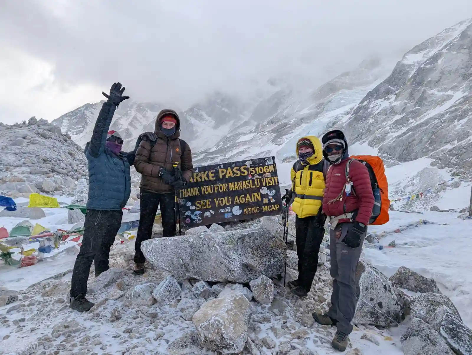
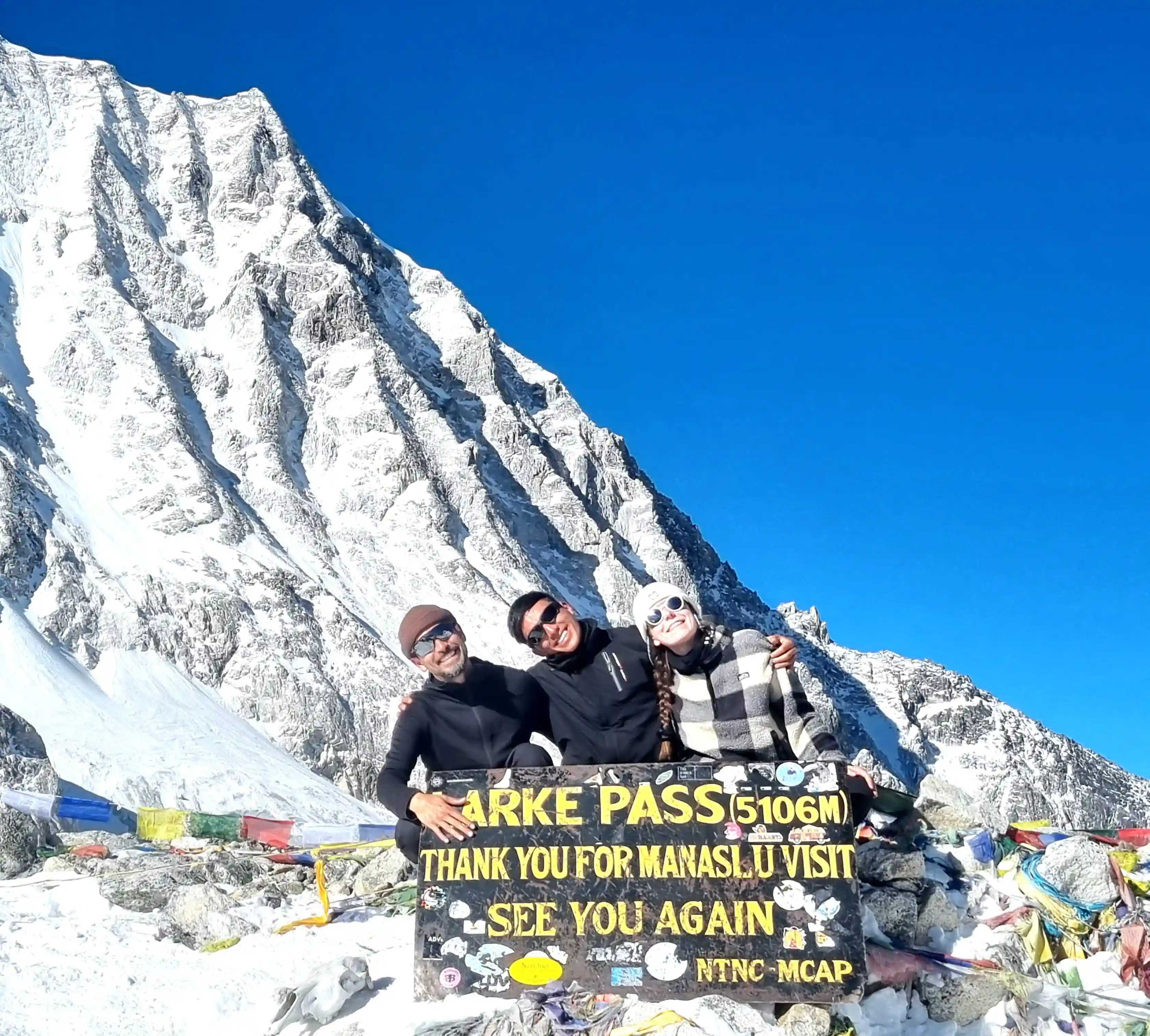
Day 20: Trek to Bhimthang via Larkya La pass (5106m/16752fts,24.5km/15.22mile)

Trekking from Dharamshala to Bhimthang through Larkya La Pass today covers about 24.5 km (15.22 miles) and takes nearly 10 to 11 hours. Early in the morning, the hike begins toward Larkya La Pass at 5,106 m (16,752 ft), climbing steep snow trails in a windy environment. From the pass, you can see Larke Peak and Punker Mountain. After descending for about 2 hours to Phedi and another 2 hours to Bhimthang. The village offers beautiful views of the Manang region and surrounding mountains, including Annapurna South.

  • Max Elevation: 5,106 meters (Larkya La Pass, the highest point between Dharamshala and Bhimthang)
  • Travel Distance: 24.5 kilometers
  • Travel Hours: 10 to 11 hours
  • Accommodation: Tea house/Lodge
  • Meals: Breakfast, Lunch, and Dinner

Day 21: Trek from Bhimthang to Goa village /Tilche (2300/7546 fts)

You can then continue your trek from Bhimthang to Goa Village/Tilche, a beautiful 26 km (16.1 miles) journey that usually takes around 6 to 7 hours. The route descends steeply along Dudhkhola, passing small hydropower projects and teahouses before reaching Chaulikharka in about 2 hours. From there, it takes around 1 hour and 15 minutes to Surtikhola, where lunch is served. After another hour, the trail follows well-built paths toward Goa. Tilche, a Gurung village with traditional homes, caves, and a suspension bridge, is reached in about an hour.

  • Max Elevation: 3,720 meters (Bhimthang, the highest point between Bhimthang and Goa Village/Tilche)
  • Travel Distance: 26 kilometers
  • Travel Hours: 6 to 7 hours
  • Accommodation: Tea house/Lodge
  • Meals: Breakfast, Lunch, and Dinner

Day 22: Trek to Dharapani and Drive to Kathmandu or Pokhara

After breakfast, you begin the final section of your trekking journey with a short walk from Tilje to Dharapani. The trail follows well-established paths through small settlements, terraced farmlands, and beautiful river valleys, offering a final opportunity to enjoy the mountain scenery and traditional lifestyle of the region. Upon reaching Dharapani, the trek officially concludes.

From Dharapani, you board a private vehicle and begin the drive toward either Kathmandu or Pokhara. The journey follows winding mountain roads through picturesque hills, rural villages, and river valleys before connecting with the main highway. Along the way, there will be stops for meals and refreshments while enjoying views of Nepal’s diverse landscapes. Upon arrival in Kathmandu or Pokhara, you are transferred to your hotel. The remainder of the day is free for personal activities, relaxation, shopping, or exploring the city at your own pace after completing your remarkable Tsum Valley and Manaslu adventure.

  • Max Elevation: 2,300 meters (Tilje, starting point)
  • Travel Distance: Approximately 7 kilometers trekking and 215 kilometers drive to Kathmandu / 133 kilometers drive to Pokhara
  • Travel Hours: 1.5 to 2 hours trekking and 7 to 9 hours drive (depending on destination and road conditions)
  • Accommodation: 3-Star Hotel (Kathmandu or Pokhara)
  • Meals: Breakfast and Lunch

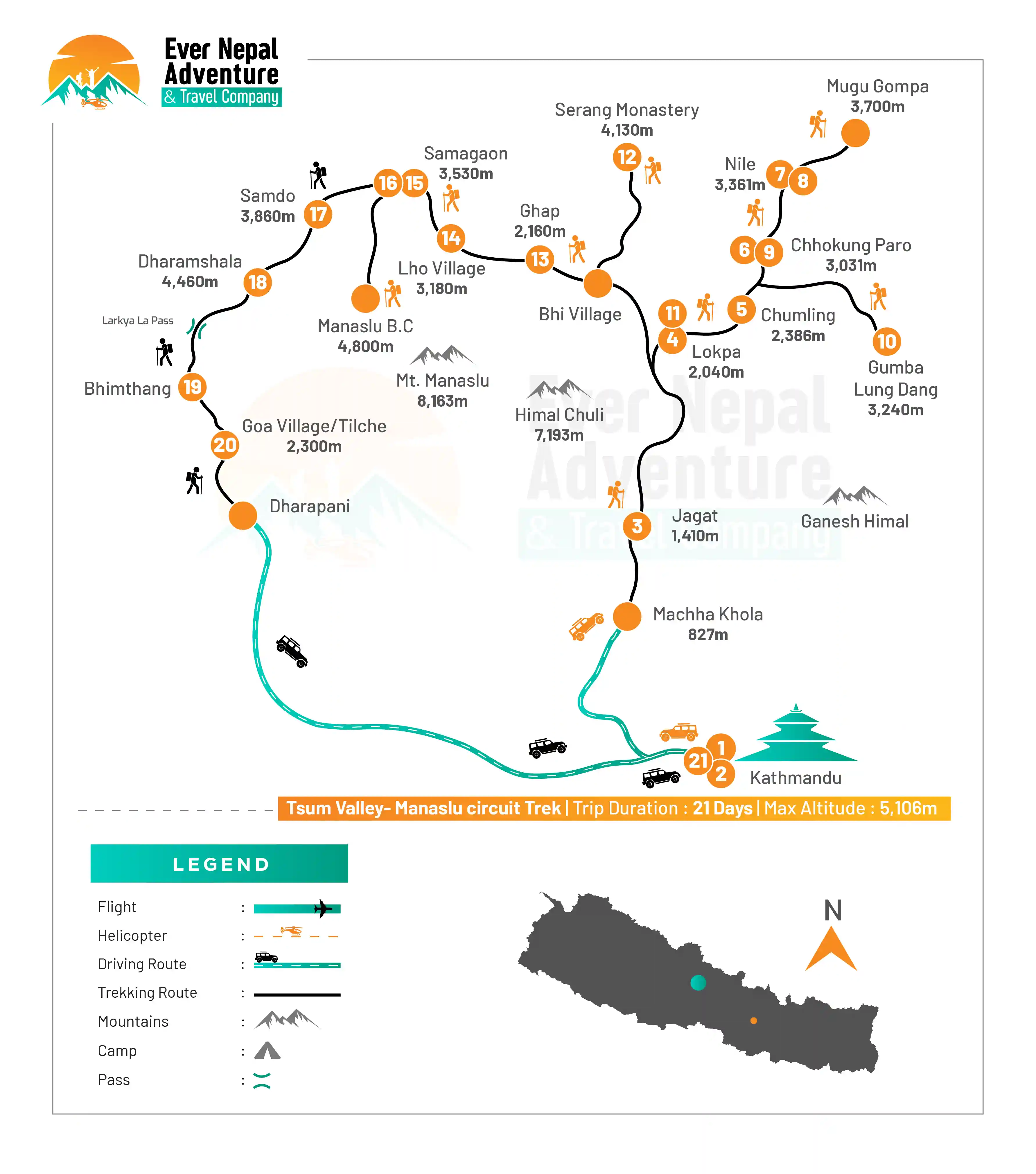
Trek Route

Ever Nepal |  Manaslu-Tsum Valley circuit Trek Route Map

What's included

  • All accommodations in lodges/tea houses during the treks 

  • All standard meals (breakfast, lunch, and dinner) during the trek

  • Transport- Tourist to Soti khola or Machha khola and Sharing jeep from Dharapani to besisahar to kathmandu(local bus are available every morning )

  • All necessary paper works, Conservation entry permits, Manasalu special permit for 7 days and TIMS permit

  • An experienced professional english speaking Guide

  • Salary, Food, Drinks, Accommodation, Transportation and Insurance for the Guide and Porter

  • Farewell dinner in Kathmandu in a typical Nepali restaurant with a cultural dance performance in the evening

  • Medical kit (carried by your trek leader)

  • Rescue operation arrangement in case of emergency conditions (funded by travel insurance)

  • Trekking map

  • All necessary paperwork and trekking permits (National Park Permit, TIMS)

  • First Aid Kit (carried by your trek leader)

  • All government taxes and official expenses

  • Guaranteed Departures

  • Lifetime Deposit

  • No Booking Fee

  • Hot drinks (tea and coffee 3 times in day)

  • Purified drinking water

What's excluded

  • International airfare

  • Nepal entry visa; you can obtain a visa easily upon your arrival at Tribhuvan

  • International Airport in Kathmandu

  • Travel insurance (if there is emergency)

  • Lunch and Dinner while you are in Kathmandu and Pokhara

  • Beverage (cold drinks and hard drinks

  • Wifi, Battery charges, hot shower

  • Your personal expenses

  • City sightseeing and entrance fees (See sightseeing and entrance fees)

  • Flight ticket Kathmandu-Pokhara-Kathmandu and Pokhara to Jomsom

  • Tips for the guide (Tipping is Expected)

  • Items and transportation are not included and mentioned in itinerary

Packing List for Tsum Valley – Manaslu Circuit Trek

For those who intend to undertake the Tsum Valley and Manaslu Circuit Trek, it is important to bring trekking equipment that has been well-tested carefully, which will be helpful for both your safety and comfort in high-altitude regions. The trekking experience will be more comfortable with proper packing.

Now, here are the lists of essential items you need to carry for this trek:

  • Head

    • Wide-brimmed sun hat

    • Warm beanie or wool hat

    • A lightweight headlamp with additional batteries.

    • UV-protected sunglasses

    • Neck gaiter or buff

    • Lip balm with SPF

    • High-SPF sunscreen

  • Hands

    • Moisture-wicking base layers

    • Warm thermal tops

  • Fleece jacket

    • Insulated down jacket

    • Waterproof and windproof outside shell

    • Quick-dry t-shirts (3–5 pairs)

    • Lightweight trekking shirts (long sleeve)

  • Lower Body

    • Trekking pants (2–3 pairs)

    • Thermal innerwear

    • Fleece trousers

    • Waterproof trekking pants

    • Pants for evenings that are comfortable with cotton fabric.

  • Footwear

    • Waterproof trekking boots (well broken in)

    • Lightweight sandals for teahouses

    • Warm wool trekking socks (4-6 pairs)

    • Gaiters for snow and mud areas.

  • Toiletries

    • Toothbrush and toothpaste

    • Soap and Travel size shampoo

    • Toilet paper and wet wipes.

    • Quick-dry towel

    • Hand sanitizer

  • Accessories

    • Trekking poles (highly recommended)

    • Large duffle bag (for porter)

    • Daypack (20–30L)

    • Sleeping bag (-10°C to -20°C rating)

    • A water bottle or hydration system that is reusable.

    • Use water purification tablets or a filter.

  • First Aid Kit

    • Diamox (for altitude sickness)

    • Painkillers (ibuprofen/paracetamol)

    • Bandages and antiseptic wipes will be provided.

    • Anti-diarrhea medicine

    • Blister care kit

    • Personal prescription medicines

  • Miscellaneous Items

    • Power Bank & Charging cables

    • Camera or smartphone

    • Extra memory cards

    • Travel adapter

    • Binoculars (optional)

  • Specific Gears for Women.
    While on the trek, there are certain essentials that women must carry in order to complete the journey successfully. Having these gears ensures comfort, hygiene, and protection throughout the trek in changing weather and altitude conditions.

  • Sports bras (comfortable and moisture-wicking)

  • Sanitary pads or tampons.

  • The thermal innerwear (top and bottom)

  • Small travel-size skin care products (sunscreen, moisturizer, cleanser)

  • Extra undergarments

  • Lightweight trekking leggings or tights.

  • Hair ties and headbands are not allowed.

  • Personal hygiene kit

Documents Required for Tsum Valley – Manaslu Circuit Trek

A good record of documents would be very helpful for a safe and smooth trekking experience in this restricted Himalayan area. For the smooth completion of the trek, the following documents and permits are to be taken along:

  • Manaslu Restricted Area Permit (RAP): A permit that is a must to access the restricted area of Manaslu. It is only issued by a registered trekking company.

  • Manaslu Conservation Area Permit (MCAP): Necessary to enter the conservation area to preserve the wildlife and natural environment.

  • Annapurna Conservation Area Permit (ACAP): This is required once you enter the Annapurna region, which is the last leg of the trek.

  • Trekkers Information Management System (TIMS Card): A mandatory registration card for trekker tracking and safety management.

  • Valid Passport: Must have at least 6 months' validity from the date of entry into Nepal.

  • Passport-size photos (4–6 copies): Required for permit processing and official documentation during the trek.

  • Travel Insurance: Should include emergency helicopter evacuation in the event of altitude sickness or accidents, and should cover high-altitude trekking. 

Frequently Asked Questions

How difficult is the Tsum Valley and Manaslu Circuit Trek?

Trekking in the Tsum Valley and the Manaslu Circuit is classified as moderately difficult trekking because of the long days of walking, distant trails, and high altitudes involved. There are also steep climbs and descents on the trail, passing through Larkya La Pass, which stands at 5,106 meters above sea level, where the weather may be difficult.

Do I need prior trekking experience?

Hiking or trekking experience would be an advantage, although not absolutely necessary, because of the time required during the trekking process and the elevation of the place. The experience can help you control your energy levels and make you comfortable while trekking.

Is altitude sickness a risk on this trek?

Yes, people can get altitude sickness above 5,000m. The days of acclimatization are very significant (such as Samagaon and the Nile). It's also important for trekkers to make sure they are well-hydrated and take it easy when they are climbing up to minimize the risk.

What is the best season for this trek?

The best time is Spring (March-May) and Autumn (September-November) when the weather is stable, and the mountain views are good. These seasons are also better for trail conditions and are much safer.

Is the Tsum Valley and Manaslu region crowded?

No, it's not a busy area of trekking; it's a quieter and more remote area of the Himalayas. There are quiet trails with a much lesser number of trekkers than the Everest or Annapurna routes.

What kind of accommodation is available during the trek?

Accommodation is mainly in basic tea houses and lodges along the route. Rooms are simple with twin-sharing beds and shared bathrooms. In higher regions like Dharamshala, facilities are very basic due to remoteness, but they are clean and managed by local families.

What type of food is available during the trek?

Meals that you will have will be simple and fresh; some meals include dal bhat, noodles, rice, vegetables, soup, pasta, or eggs. Most food is either organic or locally grown. The higher you climb, the fewer the number of choices for meals, yet still energy-filled.

Is drinking water easily available on the trek?

Indeed, water can be obtained in tea houses and in villages located on the way to the top of the mountain. You will be encouraged to drink only boiled, purified, or filtered water. It would be useful to carry water purification tablets

Do I need a guide and porter for this trek?

A local guide is essential for both the Tsum Valley and Manaslu trek since it is an unregistered trekking region. Porters are not required but are very strongly suggested since porters can take care of the heavy load, thus making the trekking process easy and safe for you.

How should I prepare physically for this trek?

You need to get ready for your trek by walking, hiking, or doing cardio workouts for several weeks before the trek. This is essential since you will be walking long distances in high altitudes.

User Review