Annapurna Circuit with Tilicho Lake For 16 Days

Tour Info

trip code

EN-0022

Starting Point/ End Point

Kathmandu

Accommodations

Lodge/ Tea House

Max Altitude

5416m (Thorung La Pass)

Duration

16 days

country

Nepal

Trip grade

Moderate

Activities

Trekking

Best Season

March, April, May, September, October, November

Overview

Annapurna Circuit - Tilicho Lake Trek is undoubtedly one of the most iconic trekking destinations of Nepal. This trek combines the classic Annapurna circuit trek with the journey towards the world's highest lake. The trek duration is 14 days and offers a mix of beautiful landscapes, including the lush valleys, alpine forests, and high mountain terrain. At the same time, on this journey, you also pass through the diverse ethnic villages.

Details

Annapurna Circuit-Tilicho Lake Trek is meant for those who want the classic Annapurna experience with an added sense of adventure. Tilicho Lake is one of the highest alpine lakes in the world, and going on this side trek provides you with a more rewarding experience. This route allows you to explore the Manangi culture and the rain-shadow terrain. You can choose this variation of the Annapurna Circuit trek if you want to feel the combination of two adventures packed into one. 

In addition, the Annapurna Circuit-Tilicho Lake trek also provides you with variety. You can see the environment and culture change every few days, ranging from subtropical forests, alpine meadows, barren arid high desert, glacier-carved valleys, and then the iconic pass crossing. You also get a wide variety of foods during this trek, as the foods change with the altitude and local culture. The trail is well-marked, and the lodges are more comfortable compared to remote regions. At the same time, the cultural mix of this region is richer, especially in places such as Chame, Manang, and Marpha.
Highlights

  • Hike through some of the most picturesque and famous mountain trails of Nepal.

  • Visit Tilicho Lake, which is considered the highest lake in the world and lies 4,920m above sea level.

  • Cross the amazing Thorung La Pass, 5,416m, with spectacular views of the mountains. While in the area, visit the traditional villages of Manang, Pisang, and Marpha.

  • Observe the changing landscapes from green forests to dry mountain deserts.

  • Visit the holy Muktinath Temple, which is sacred for Hindus and Buddhists.

  • Enjoy a sunrise view from Poon Hill at 3,210 meters over the Annapurna and Dhaulagiri ranges.

  • Have overnight stays in cozy teahouses and meet the friendly locals.

  • See old monasteries, prayer wheels, and Mani walls lining the trail.

  • Adventure, culture, and nature all in one journey.

Itinerary

Day01: Arrival in Kathmandu

Upon arrival in Kathmandu, you are welcomed by our representatives at the Tribhuvan International Airport. After that, we move you to your 3-star hotel. In this hotel, you take a short rest. Then, you are invited to the briefing session for the trekking activities. At this session, you meet your trekking guide, who discusses the preparations for the trekking activities. After completing this session, you begin to handle the basic things needed for the activities. Following this, you shall be invited to a welcome dinner, after which, you shall spend the night at a 3-star hotel. 

  • Max Elevation: 1,324 meters (4,344 feet)
  • Travel Distance: 5 to 6 kilometers
  • Travel Hours: 20 to 30 minutes
  • Accommodation: 3-star standard hotel 
  • Meal: Welcome dinner

Day 02: Full Day Guided Sightseeing Kathmandu Tour

After breakfast at the hotel, your sightseeing tour starts around 8 AM. You can have a private vehicle for the whole day, making the trip comfortable and easy. A professional tour guide shall also be with you to explain the places you visit. The tour follows a simple schedule because it gives you enough time to explore each site without rushing, so you can move at a relaxed pace. You stop at several important heritage sites around the Kathmandu Valley. Each place has its own history and cultural value, which your guide helps you understand.

A. Pashupatinath (World Heritage Site):

Pashupatinath Temple is one of the most important Hindu temples dedicated to Lord Shiva. It stands on the banks of the Bagmati River. Non-Hindus cannot enter the main temple, but you can still see the temple complex and daily rituals clearly from the eastern side of the river. The temple has a two-tiered pagoda design and is well-known worldwide.

B. Boudhanath (World Heritage Site):

Boudhanath is one of the most sacred Buddhist sites in Kathmandu. Built in the 5th century, the large stupa has four pairs of Buddha’s eyes facing all directions, symbolizing awareness. You can see many Buddhist devotees walking around the stupa while rotating prayer wheels.

C. Patan Durbar Square (World Heritage Site):

Located in central Lalitpur, Patan Durbar Square showcases traditional Newari architecture at its finest. Many of its buildings were created during the Malla period, known for rich craftsmanship and art.

D. Swayambhu Stupa / Monkey Temple:

Located on a small hill, Swayambhu offers a wide view of the Kathmandu Valley. It is also called the Monkey Temple because many monkeys live around the stupa. This site is very important to both Buddhists and Hindus.

Max Elevation: 1,450 meters (Swayambhu Stupa, highest point in the Kathmandu sightseeing tour)
Travel Distance: 25 to 30 kilometers (total driving between sites)
Travel Hours: 6 to 7 hours
Accommodation: 3 Star Standard Hotel
Meal: Breakfast

Day 03: Drive from Kathmandu-Besisahar(760m);Drive to Dharapni(1900m)

On the first day of your tourism journey, you take a long but scenic drive from Kathmandu to Besisahar before moving on to Dharapani. The drive lasts for roughly 9 to 10 hours and covers an average distance of 235 km. During this drive, you pass through the mountain roads, green and lush valleys, and many terraced fields. This drive also allows you to take a brief glimpse into the rural lifestyle of rural Nepal.

  • Max Elevation: 1,900 meters (Dharapani)

  • Travel Distance: 235 kilometers

  • Travel Hours: 9 to 10 hours

  • Accommodation: Overnight stay at a tea house or a lodge

  • Meals Included: Breakfast, Lunch, Dinner

  • Drinks: Tea and Coffee

Day 04: Trek from Dharapani - Chame(2700m)

Starting from the second this day, the trek officially begins. You begin the trek from Dharapani and follow the trail alongside the Marsyangdi River. As you move along the trekking route, it takes you through the beautiful pine forests and a few traditional stone villages. The trek lasts for roughly 5 to 6 hours and covers roughly 14.5 km. At the end of the trek for the day, you reach Chame, which is the headquarters of Manang District. This small village is surrounded by beautiful peaks, meaning that as you rest, you can view the surrounding mountains and breathe the fresh air.

  • Max Elevation:  2,700 meters (Chame)

  • Travel Distance: 14.5 kilometers

  • Travel Hours: 5 to 6 hours

  • Accommodation: Overnight stay at a tea house or a lodge

  • Meals Included: Breakfast, Lunch, Dinner

  • Drinks: Tea and Coffee

Day 05: Trek from Chame -Upper Pisang(3300m/10827 ft)

This journey takes you through the dense forests and the open valleys. You can enjoy the views of the mountains such as Lamjung Himal and Annapurna II on the way. The journey is fairly simple yet a bit tough, as most of the day is filled with ascending trails with a few descents. Since at this point of the journey, you are in rural Nepal, the road is rather rugged. The entire trek for the day takes around 5 to 6 hours and covers a total distance of 13.2 km.

  • Max Elevation: 3,300 meters (Upper Pisang)

  • Travel Distance: 13.2 kilometers

  • Travel Hours: 5 to 6 hours

  • Accommodation: Overnight stay at a tea house or a lodge

  • Meals Included: Breakfast, Lunch, Dinner

  • Drinks: Tea and Coffee

Day 06: Trek from Upper Pisang-Nagwal(3670m/12037ft)

After leaving Upper Pisang, you trek through the alpine forests and small villages before you reach the village of Nagwal. You finish the fourth day's trek in around 4 to 5 hours, covering a distance of roughly 9.6 km while taking in the scenic views. Since the trek is relatively short, you can freely relax at Nagwal. The village is surrounded by the views of Annapurna II, which makes the trek worth every effort.

  • Max Elevation: 3720 meters (Between Upper Pisang and Nagwal)

  • Travel Distance: 9.6 kilometers

  • Travel Hours: 4 to 5 hours

  • Accommodation: Overnight stay at a tea house or a lodge

  • Meals Included: Breakfast, Lunch, Dinner

  • Drinks: Tea and Coffee

Day 07: Trek from Nagwal- Manang (3520m/11545ft)

The fifth trekking day begins with a comforting local breakfast. Similar to the previous day, you shall only spend a few hours trekking as the trek for this day only lasts for around 4 to 5 hours. During this journey, you shall cover roughly 9.7 km while taking in the view of the small Buddhist shrines, Mani walls, and yak pastures. As you witness these views and follow the Marsyangdi Valley, you end the day at Manang – a traditional valley which is rich in culture, flat-roofed houses, prayer wheels, and a warm local community.

  • Max Elevation: 3670 meters (Highest Point Between Nagwal and Manang)

  • Travel Distance: 9.7 kilometers

  • Travel Hours:  4 to 5 hours

  • Accommodation: Overnight stay at a tea house or a lodge

  • Meals Included: Breakfast, Lunch, Dinner

  • Drinks: Tea and Coffee

Day 08: Acclimatisation Day/Rest Day

Although trekking is indeed a fun and refreshing activity, you do have to note that you need to acclimatise as you ascend. Therefore, on the sixth day, you rest at Manang and acclimatise. Doing so helps your body adjust to the higher altitude. You can explore the village, visit the local monastery, or simply hike up to the Ice Lake (4620m) or Milarepa Cave (4120m) as you would do on a regular tour while taking in the panoramic view of the mountains.

  • Max Elevation: 4,620 meters (Highest Point Between Manang and Ice Lake)

  • Travel Distance: 6 kilometers

  • Travel Hours: 3 to 4 hours

  • Accommodation: Overnight stay at a tea house or a lodge

  • Meals Included: Breakfast, Lunch, Dinner

  • Drinks: Tea and Coffee

Day 09: Trek from Manang Village to Tilicho Base Camp(4200m)

After you have your breakfast, you follow the trail as it leaves the main circuit trek and heads towards the Tilicho Base Camp. Compared to the previous day, this trekking day is long and tough as you need to cover roughly 20km within a 7 to 8-hour time span. You walk through the rocky terrain with less vegetation while being surrounded by cliffs and icy ridges. The day ends with a well-deserved rest at the tea house of a lodge at Tilicho Base Camp.

  • Max Elevation: 4,200 meters (Highest Point Between Manang and Tilicho Base Camp)

  • Travel Distance: 20 kilometers

  • Travel Hours: 7 to 8 hours 

  • Accommodation: Overnight stay at a tea house or a lodge

  • Meals Included: Breakfast, Lunch, Dinner

  • Drinks: Tea and Coffee

Day 10: Hike to Tilicho Lake (4,920m;3 hours) and return to base camp, then Trek to Shree Kharka(4,080m)

The eighth day of this trekking journey begins with a hike to Tilicho Lake, which is one of the highest lakes in the world. The lake has deep blue waters and lies between the surrounding snowy mountains. Just the view here is worth every step. After spending some time in the lake, you return to the base camp and continue trekking towards the Shree Kharka. The total journey takes around 7 to 8 hours, and you cover around 11km over time.

  • Max Elevation: 4,920 meters (Highest Point Between Tilicho Base Camp and Tilicho Lake)

  • Travel Distance: 11 kilometers

  • Travel Hours: 7 to 8 hours 

  • Accommodation: Overnight stay at a tea house or a lodge

  • Meals Included: Breakfast, Lunch, Dinner

  • Drinks: Tea and Coffee

Day 11: Trek from Shree Kharka -Yak Kharka (4,060m)

Trek for the ninth tourism day begins with a descent before you gradually climb again towards the Yak Kharka. You can and should trek slowly on this day as the route is rather steep. Therefore, you have around 4 to 5 hours to cover a reasonable distance of 8.4 km. You trek past the many meadows and yak pastures where you can see the yak herders. At this phase of the trek, you are far from any forms of cities and towns, so the air is fresh and the views of the mountains make everything well worth the trip.

  • Max Elevation: 4,080 meters (Highest Point Between Shree Kharka and Yak Kharka)

  • Travel Distance: 8.4 kilometers

  • Travel Hours: 4 to 5 hours

  • Accommodation: Overnight stay at a tea house or a lodge

  • Meals Included: Breakfast, Lunch, Dinner

  • Drinks: Tea and Coffee

Day 12: Trek from Letdar - Thorung High camp(4800m/15749ft)

The tenth day of this tourism journey is a bit shorter but a bit steeper when compared to the previous days. You trek towards Thorung High Camp, which is the final stop before crossing the famous Thorung La Pass. The path towards Thorung High Camp is rocky and exposed to nature. While on this trek, you can also witness the panoramic views of the snowy mountains. The trek for this day is around 4 to 5 hours long, during which you need to cover the distance of approximately 9.5 km. You reach the destination fairly early, which gives you plenty of time to rest and enjoy the views.

  • Max Elevation: 4,800 meters (Highest Point Between Letdar and Thorung High Camp)

  • Travel Distance: 9.5 kilometers

  • Travel Hours: 4 to 5 hours

  • Accommodation: Overnight stay at a tea house or a lodge

  • Meals Included: Breakfast, Lunch, Dinner

  • Drinks: Tea and Coffee

Day 13: Trek from High Camp-Muktinath(3700m) via Thorung La Pass(5416m)

This is the most challenging and rewarding part of your travel on the Annapurna Circuit-Tilicho Lake. You start this trek before dawn with the aim of crossing the Thorung La Pass at an altitude of 5461 m, which is the highest point of this journey. To reach here, you need to climb a steep ascent, for which you need to be in optimal fitness. That said, this part of the journey does allow you to witness the stunning views of the Annapurna, Dhaulagiri and many other peaks. After you enjoy the view, you descend towards Muktinath, which is a sacred site.

  • Max Elevation: 5,416 meters (Highest Point Between High Camp and Muktinath via Thorung La Pass)

  • Travel Distance: 13 kilometers

  • Travel Hours: 7 to 8 hours

  • Accommodation: Overnight stay at a tea house or a lodge

  • Meals Included: Breakfast, Lunch, Dinner

  • Drinks: Tea and Coffee

Day 14: Trek to Marpha(2680m) via Kagbeni village and Jomsom

Starting on the twelfth day of tourism, you begin your return journey. It begins at Muktinath, from where you follow the trail that descends through the lands of Kagbeni and Jomsom. This part of the journey offers you the beautiful view of the Kali Gandaki Valley. Although the route is 24.5km, you can cover this distance fairly quickly, as you only need around 5 to 6 hours to complete it. The destination for this day is Marpha, which is a beautiful Thakali village, popular for its apple orchards and stone-paved alleys. This village also perfectly blends local culture and mountain charms – making it a delightful stop.

  • Max Elevation: 3,700 meters (Highest Point Between Muktinath and Marpha via Kagbeni and Jomsom)

  • Travel Distance: 24.5 kilometers

  • Travel Hours: 5 to 6 hours

  • Accommodation: Overnight stay at a tea house or a lodge

  • Meals Included: Breakfast, Lunch, Dinner

  • Drinks: Tea and Coffee

Day 15:Drive to Tatopani(1140m) and Trek to Ghorepani(2870m)

As the second last day of the trip, this trekking and tourism journey nears its end. You begin this day with a short drive of 2 to 3 hours, which takes you to Tatopani – a place popular for its natural hot springs and a perfect spot to relax. After a brief break at Tatopani, you walk through the forests and begin your uphill trek towards Ghorepani. This combination of trek and drive takes roughly 7 to 8 hours, and you end the day at a local tea house or a lodge for some well-deserved rest.

  • Max Elevation: 2,870 meters (Highest Point Between Tatopani and Ghorepani)

  • Travel Distance: 26 kilometers

  • Travel Hours: 7 to 8 hours

  • Accommodation: Overnight stay at a tea house or a lodge

  • Meals Included: Breakfast, Lunch, Dinner

  • Drinks: Tea and Coffee

Day 16: Detour to Poon Hill (3210m), Trek to Hile(1460m) & Drive to Pokhara

On the final day of the journey, you start early and head towards Poon Hill, which is one of Nepal's most famous viewpoints. From this point, you can view the beautiful view of the surrounding Annapurna and Dhaulagiri peaks. After enjoying the view for a while, you trek downhill towards Hile and then take a drive back to Pokhara, marking the ending of your trekking journey. The travel duration is rather short as you only need to travel for 2 to 3 hours.

  • Max Elevation: 3,210 meters (Highest Point Between Ghorepani and Poon Hill)

  • Travel Distance: 18 kilometers

  • Travel Hours: 2 to 3 hours

  • Accommodation: Hotel Splendid View

  • Meals Included: Breakfast, Lunch, Dinner

  • Drinks: Tea and Coffee

Trek Route

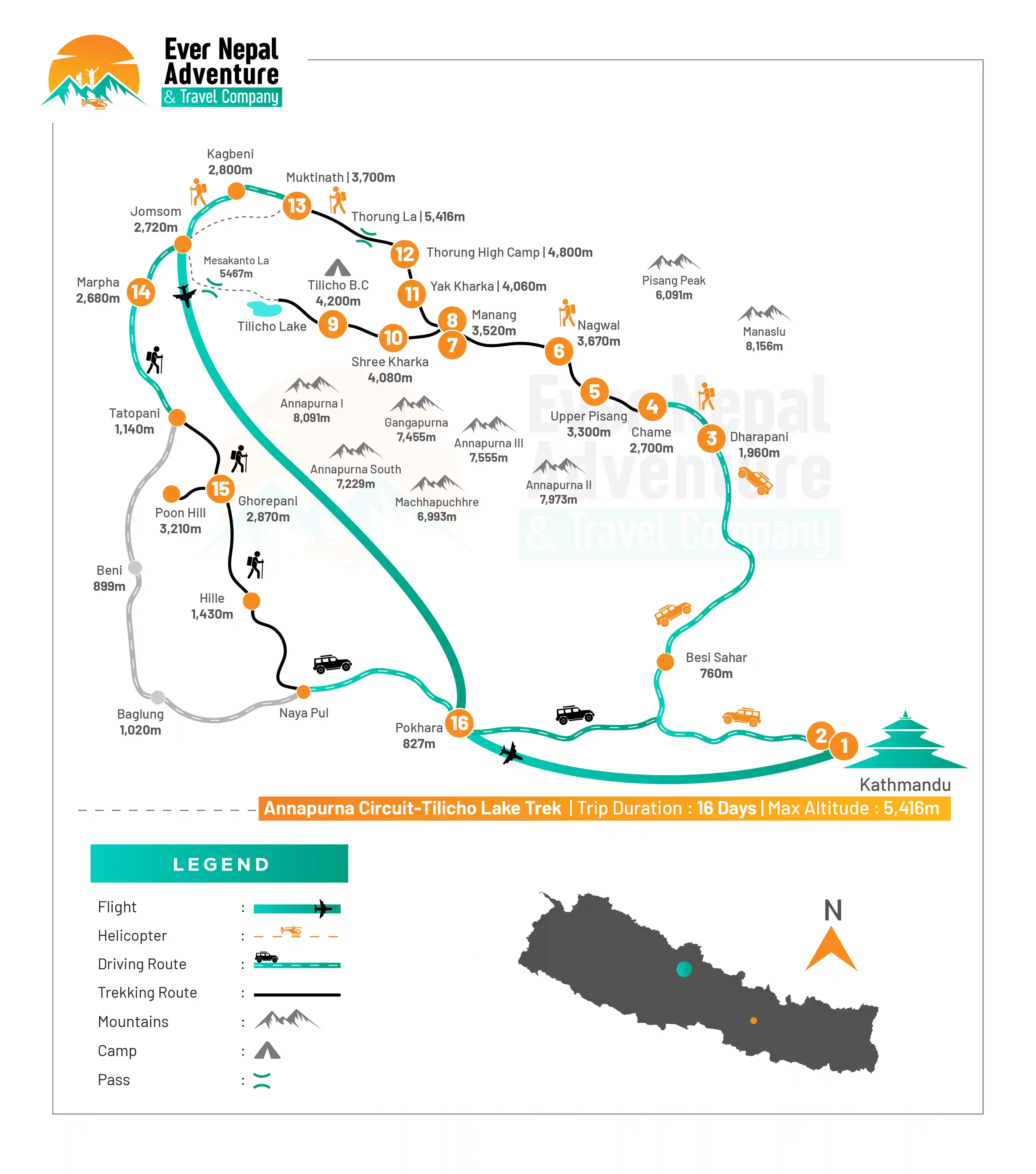
Annapurna Circuit-Tilicho Lake Route Map |  Ever Nepal

Packing List for Annapurna Circuit-Tilicho Lake

If you are thinking about the Annapurna Circuit with Tilicho Lake, packing smart is very essential as you will be moving from a warm valley to an extremely cold high altitude area. Proper equipment helps to keep you safe, warm and comfortable while on the trail.

Head

  • Wide-brim sun hat
  • Warm woolen beanie
  • UV-protected sunglasses
  • High SPF sunscreen
  • Lip balm with SPF
  • Lightweight headlamp
  • Neck gaiter or buff

Hands

  • Waterproof gloves
  • Insulated warm gloves

Upper Body

  • Moisture-wicking base layers
  • Quick-dry t-shirts
  • Fleece jacket
  • Heavy insulated down jacket
  • Waterproof and windproof jacket
  • Trekking shirts that are breathable (long sleeve)
  • Light puffy jacket (compressible)

Lower Body

  • Thermal innerwear
  • Waterproof trekking pants
  • Fleece pants
  • Lightweight trekking trousers
  • Lightweight, comfortable cotton pants (for lower elevations)

Footwear

  • Waterproof trekking boots
  • Lightweight slippers (for use in the teahouse)
  • 4 to 5 pairs of woolen trekking socks
  • Gaiters for snowy/muddy areas

Toiletries

  • Toothbrush and toothpaste
  • Toilet paper
  • Hand sanitizer
  • Travelling sized soap and shampoo
  • Quick-dry towel
  • Moisturizer and sunscreen

Accessories

  • Trekking poles
  • Large duffle bag
  • Daypack (20L to 30L)
  • Water bottle or hydration bladder
  • Water purification tablets/filter
  • A sleeping bag is recommended (–10°C to –20°C)

First Aid Kit

  • Diamox (for altitude sickness)
  • Painkillers (ibuprofen/paracetamol)
  • Antiseptic wipes
  • Bandages and gauze
  • Blister care tape
  • Anti-diarrhea medicine
  • Personal prescribed medicines

Miscellaneous Items

  • Power bank
  • Power cord and travel adaptor
  • Camera or smartphone
  • Binoculars (optional)
  • Snacks (energy bars, nuts, chocolates)

Specific gear for Women

On a Annapurna Circuit-Tilicho Lake Trek; women trekkers may take a little extra with them to make it easier to stay comfortable in the changing weather conditions around the Everest region of Mount Everest.

  • Comfortable undergarments
  • Sports bra
  • A sanitary pad/tampon.
  • Travel size shampoo and hygiene care products
  • Moisturizer and sunscreen
  • Skin cleanser
  • Fleece headband
  • Comfortable leggings or tight thermal wear

Documents

There are some documents that are necessities for the successful completion of Annapurna Circuit – Tilicho Lake trek. These documents guarantee a secure, lawful and trouble free walking experience. The following documents are required:

  1. Annapurna Conservation Area Permit (ACAP): It is the permit that you have to secure to enter Annapurna Conservation Area. You can get it from the Nepal Tourism Board office, Kathmandu or Pokhara. Foreigners have to pay NPR $23 (3000), SAARC nationals pay NPR $1 (1000) and Nepalis pay NPR(100).
  2. TIMS Card (Trekkers Information Management System): This permit is mandatory for the trekker registration and monitoring of the trekker status in the Annapurna region. It can be obtained from Nepal Tourism Board office in Kathmandu or Pokhara, as well as from registered trekking agencies. It's NPR 2,000 ($15) per person for trekkers on their own and NPR 1,000 per person for trekkers who hired an agency.
  3. Passport: An original passport with its validity period not to be less than 06 months from the date of entry. This is crucial for any processing steps for permits, identity checks, and travel documents en-route along the trip.
  4. Passport Size Photos: Ensure that you have 2 to 4 passport size photos at your fingertips, for permit applications or official registration purposes. Additional copies are recommended for emergencies or additional documents.
  5. Travel Insurance: Travel insurance is compulsory for Annapurna Circuit – Tilicho Lake trek. It should definitely cover high altitude trekking and emergency evacuation by helicopter, given that it may be hard to reach and costly to do so in remote areas.

What's included

  • Shuttle service to Bus Park

  • Accommodations during the trip in hotels with a family environment.

  • Transportation from Kathmandu to Besisahar by local/ tourist transport and

  • Then to Dharapani via private Jeep

  • Transportation from Marpha -Tatapani(Local bus) and back to Pokhara (Private

  • Jeep from Hile)

  • Meal (Breakfast, Lunch & Dinner)

  • Accommodation in Pokhara (one night with B/B plan)

  • Hot drinks ( Every meal, each cup)

  • Licensed English-speaking trekking guide.

  • Guide expenses, including meals, insurance, salary, lodging, and all

  • necessary equipment.

  • Mentioned gears

  • First Aid Medical Kit carried by the guide.

  • All the required permits (ACAP permit & TIMS) and paperwork.

  • All government and local taxes and official expenses.

  • Farewell dinner at the end of the trek.

What's excluded

  • Any airfare charges (domestic and international).

  • Visa charges.

  • Your travel and medical insurance.

  • Personal expenses such as shopping, bar bills, hot shower, phone, laundry,

  • titbits etc.

  • Personal gear and clothing.

  • Extra drinks

  • Extra accommodation in Pokhara.

  • Emergency expenses, such as expenses on a charter helicopter evacuation.

  • Tour in Pokhara and Entrance fee in Kathmandu and Pokhara

  • Tips for guides and porters.

  • Any expenses not listed in Cost Includes.

Frequently Asked Questions

What is the difficulty level of the Annapurna Circuit with Tilicho Lake?

Partly from the high altitudes of the pass, Thorong La Pass (5416m), and partly from the length of the walking days, this is a moderate to difficult trek. Steep and rocky trails are also part of the "side trips" away from Tilicho Lake. Having good fitness and acclimatization are really essential to a safe and fun trekking experience.

How many days are needed for this trek?

Annapurna Circuit with Tilicho Lake typically lasts for 14 to 18 days depending on your hiking speed and the route you design. Other trekkers may extend it to acclimatize or side explore. The location and high altitude of the side trip to Tilicho Lake adds 2 to 3 days to this trek.

What is the best time to do this trek?

Spring and autumn (March to May and September to November) are the best seasons. These months feature mild, sunny, and clear skies and mountains. The winter season is very cold and snowy, and in the lower area, heavy rains and landslides occur during the monsoon season.

Is altitude sickness a risk on this trek?

The climb does go above 5000 meters which means that there is a risk of altitude sickness. Signs are headache, nausea and dizziness. It is very important to acclimatize, rise slowly, drink plenty of water and get rest days. Saving Diamox and being able to make use of it and knowing when to descend is also very recommended.

Do I need permits for this trek?

Yes, you need a TIMS card and ACAP (Annapurna Conservation Area Permit). All trekkers have to have these. They assist with the conservation work and tracking of the trekking. It is possible to get permits either in Kathmandu or Pokhara before beginning the trek.

What type of accommodation is available?

The majority of the accommodation is in teahouses and lodges along the route. Accommodations are simple, typically comprising a shared bathroom, and twin beds. Facilities become more simple at higher altitudes like Tilicho Base Camp. Comfort will decrease as you climb higher, but there will be warm meals at the ready.

What kind of food is available during the trek?

The teahouses serve basic food such as dal bhat, noodles, pasta, rice, soup, potatoes etc. Food that is rich in energy is common. The menu changes a bit as you go up the floors but meals are fresh and daily cooked. It's also a good idea to bring snacks such as protein bars and nuts.

How cold does it get on this trek?

Temperatures vary widely, as the daytime temperature is warm in the lower regions, but in the higher parts of the passes such as Thorong La Pass, or in the ice and snow of Tilicho Lake, temperatures can drop below -10°C at night. Layering is essential for comfort and safety, using down jackets, thermals and gloves.

Is prior trekking experience required?

Previous experience is not required, but is useful. This walk is suitable for beginners provided they are physically fit and ready for long walking times. Exercising with the cardio and hiking before the hike makes it so much more comfortable and more comfortable.

Is mobile network and internet available?

Mobile network is available in many lower and mid-altitude villages, but it becomes weak or unavailable at higher elevations. Some teahouses offer paid Wi-Fi, but it is slow. So, it is best to inform family in advance about limited connectivity during the trek.

User Review