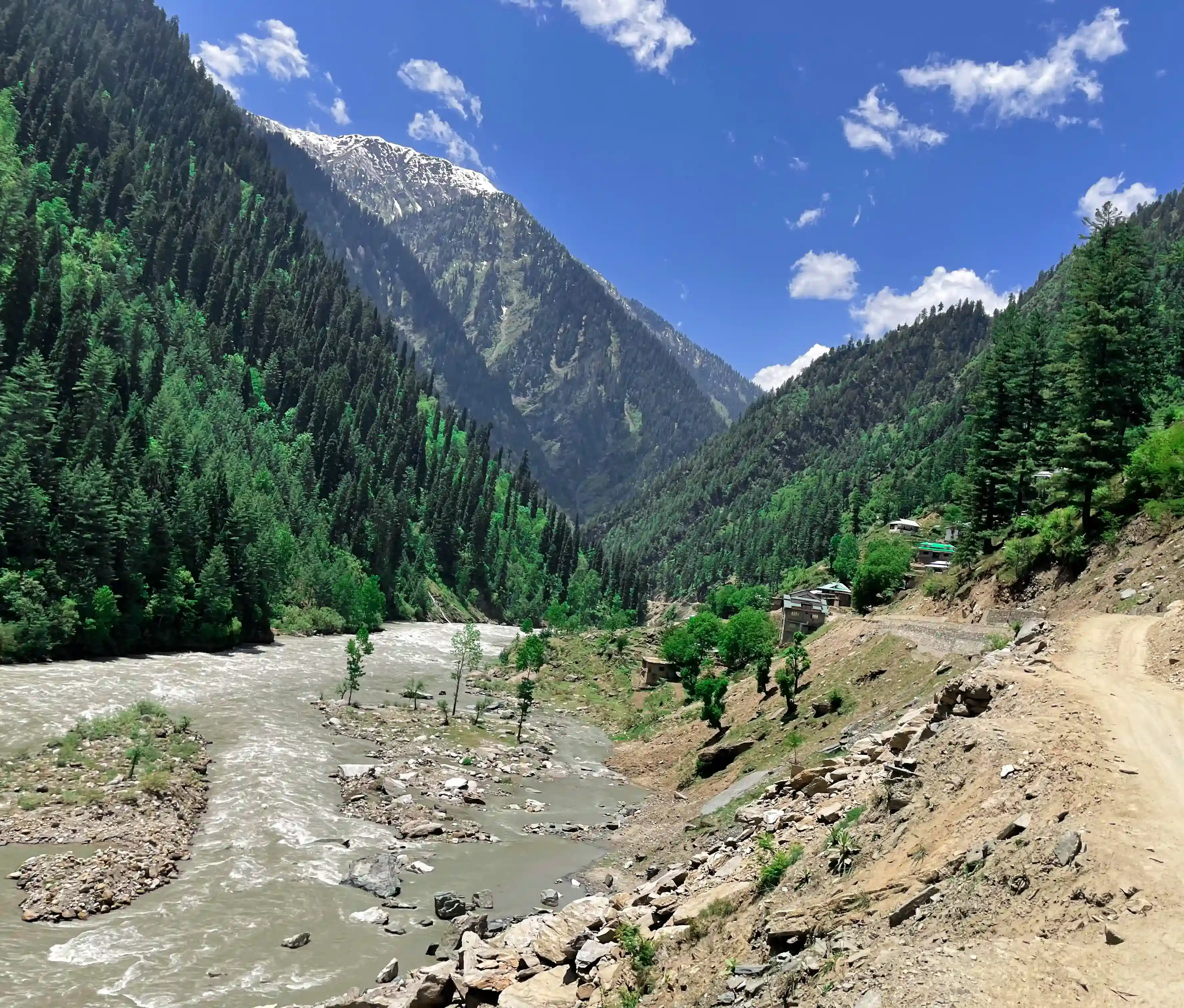
Limi Valley Trek for 21 Days

Tour Info

trip code

02

Starting Point/ End Point

Kathmandu

Accommodations

Lounge and tea house

Max Altitude

4,995

Duration

21 days

country

Nepal

Trip grade

Moderate

Activities

Trekking

Best Season

February, March, April, May, June, September, October, November and December

Overview

Limi Valley Trek is a remote and restricted trek in the Humla region of far-west Nepal, close to the Tibetan border. Special permits are required, and you must travel with a licensed guide. Trek reaches a high altitude of around 4,995 meters at Nyalu La Pass, so proper acclimatization and physical fitness are very important. Trail passes through dry, cold landscapes with limited vegetation, and the weather can change quickly, especially at higher elevations. Best seasons for this trek are spring (April to June) and autumn (September to November), when the weather is more stable and views are clear.

Accommodation during the trek is basic, mostly in local tea houses or simple lodges, and sometimes camping is needed in more remote areas. Meals are simple and locally prepared, usually including dal bhat, noodles, and soups. There are very limited modern facilities such as internet, electricity, or hot showers, so trekkers should be prepared for a simple lifestyle. The journey includes flights to Nepalgunj and Simikot, followed by long walking days through isolated villages and high passes. Travel insurance that covers high altitude trekking and emergency evacuation is strongly recommended for safety.
Highlights

  • Explore the three villages of Limi Valley, Til, and Halji (with the 800-year-old Rinchhen Ling Monastery), and Jang near the hot spring

  • Meet local people from Tibetan Buddhist, Shakya, Thakuri, and Khas communities in Humla villages

  • Walk along the Karnali River from Simikot towards Limi Valley

  • Visit old monasteries in Kermi and learn about local culture and traditions

  • Explore Namkha Khyung Dzong Monastery in Yalbang and Dhungkar Choezom Monastery in Tumkot

  • Cross high mountain passes like Nara La, Langdoga, and Nyalu La

  • Walk on an ancient trade route that connects Limi Valley with Mansarovar

  • Enjoy views of Mt. Kailash, Mt. Api, Kanjiroba, and Mt. Saipal on clear days

  • Visit famous heritage sites in Kathmandu like Durbar Square, Swayambhunath, and Boudhanath

Itinerary

Day 01: Arrival in Kathmandu (1,350 m)

After landing at Tribhuvan International Airport, you complete the arrival process and collect your luggage. Our representative meets you at the airport and transfers you to your hotel in Kathmandu. You can rest and recover from your flight. Later in the day, there will be a short briefing about the trek. The guide will explain the route, safety details, accommodation, and meals. In the evening, you can enjoy a welcome dinner at a local restaurant, where you can try Nepali food and meet other trekkers.

  • Max Elevation: 1,350 meters (Kathmandu)

  • Travel Distance: 6 to 8 kilometers

  • Travel Hours: 20 to 30 minutes

  • Accommodation: 3-star hotel

  • Meal: Dinner

Day 02: Free day in Kathmandu

After breakfast, your sightseeing tour starts around 8 AM. You travel in a private vehicle with a professional guide who explains each site in a simple and clear way. The day is relaxed, so you can explore comfortably without rushing.

A. Pashupatinath (World Heritage Site)

Pashupatinath is one of the most important Hindu temples in Nepal, dedicated to Lord Shiva. It is located on the banks of the Bagmati River. Non-Hindus are not allowed inside the main temple, but you can clearly see the temple complex and daily rituals from the outside area. The temple is also known for its traditional pagoda-style architecture and spiritual atmosphere.

B. Boudhanath (World Heritage Site)

Boudhanath is one of the largest and most sacred Buddhist stupas in Nepal. It was built in the 5th century and is an important center for Tibetan Buddhism. The stupa has Buddha’s eyes painted on all four sides, symbolizing awareness. You can see monks and visitors walking around the stupa while spinning prayer wheels in a peaceful environment.

C. Patan Durbar Square (World Heritage Site)

Patan Durbar Square is located in Lalitpur and is famous for its rich Newari architecture. Most of the structures were built during the Malla period. The square includes old palaces, courtyards, and temples with detailed wood and stone carvings. It is a great place to understand the history and art of the Kathmandu Valley.

D. Swayambhunath Stupa (Monkey Temple)

Swayambhunath is a hilltop stupa that offers a wide view of Kathmandu Valley. It is one of the oldest religious sites in Nepal and is important for both Buddhists and Hindus. The area is also known as the Monkey Temple because of the many monkeys living around it. It is a peaceful place for walking and enjoying the view.

  • Max Elevation: 1,450 meters (Swayambhunath)

  • Travel Distance: 25 to 30 kilometers (total driving)

  • Travel Hours: 6 to 7 hours

  • Accommodation: 3-star hotel

  • Meal: Breakfast

Day 03: Fly from Kathmandu to Nepalgunj (150 meters)

You take an early flight from Kathmandu Domestic Airport to Nepalgunj. The flight is around 50 minutes and offers a nice aerial view of hills and, on clear days, distant Himalayan peaks during take-off. Gradually, the landscape changes into the flat Terai region as you descend toward the south-western part of Nepal. After landing at Nepalgunj Airport, you can feel a noticeable increase in temperature compared to Kathmandu. Nepalgunj is a major city in the Terai region, close to the Indian border, and has strong cultural influence from nearby Indian towns. After transferring to your hotel, you can relax or take a short walk in the evening. Streets are lively, and you can try some local food before resting in an air-conditioned room.

  • Max Elevation: 150 meters (Nepalgunj)

  • Travel Distance: 520 kilometers (flight distance)

  • Travel Hours: 45 to 60 minutes flight

  • Accommodation: 3-star hotel

  • Meal: Breakfast, Lunch, and Dinner

Day 04: Fly from Nepalgunj to Simikot (2,950 meters)

You head to Nepalgunj airport and take a morning flight to Simikot after having breakfast at your hotel. Flight is short but very scenic, as you gradually move from the flat Terai region to the remote mountain landscapes of Humla. On arrival, you can notice a clear change in climate, geography, and lifestyle compared to lower regions. Simikot is the district headquarters of Humla and one of the main entry points for treks toward Limi Valley and Mount Kailash routes. The village is surrounded by hills and offers views of the Karnali River valley. It is home to Tibetan Buddhist, Thakuri, and Khas communities who live a simple and welcoming lifestyle. In the afternoon, you can explore the village, visit local monasteries, and observe daily life in this remote area.

  • Max Elevation: 2,950 meters (Simikot)

  • Travel Distance: 180 kilometers (flight distance)

  • Travel Hours: 45 to 60 minutes flight

  • Accommodation: Lodge/Tea House

  • Meal: Breakfast, Lunch, Dinner

Day 05: Trek to Dharapuri (2,300 meters)

The first trekking day starts from Simikot toward Dharapuri. Trail begins with a short uphill climb for about one hour. After that, you cross a small pass around 3,000 meters and then slowly descend along the Karnali River. Then the route slowly moves through the pine forests and a few small settlements along the way. During the walk, you may see local people carrying daily supplies, firewood, and other goods on steep mountain trails. After some ups and downs, you finally reach Dharapuri, a small farming village where both Hindu and Buddhist communities live together. You can stay near the riverside area, enjoying the peaceful natural surroundings.

  • Max Elevation: 3,000 meters

  • Travel Distance: 10 to 11 kilometers

  • Travel Hours: 5 hours

  • Accommodation: Tea house / Camping

  • Meal: Breakfast, Lunch, Dinner

Day 06: Dharapuri to Kermi (2,650 meters)

You can continue the trek after having breakfast along the Karnali River. Then trail goes through a mix of uphill and downhill sections on narrow paths above the river. After some time, you descend into cultivated fields where locals grow barley, buckwheat, rice, and potatoes. The walk is steady and scenic before reaching Kermi in the afternoon. Kermi is a peaceful village mainly inhabited by Buddhist communities. It is known for its traditional farming lifestyle and simple way of living. In the afternoon, you can explore the village and nearby monasteries. Kermi Laikyo Gompa and Lhundrup Choeling Gompa are important cultural sites and are located a short walk from the campsite.

  • Max Elevation: 2,650 meters (Kermi)

  • Travel Distance: 10 to 11 kilometers

  • Travel Hours: 5 to 6 hours

  • Accommodation: Tea house / Lodge

  • Meal: Breakfast, Lunch, Dinner

Day 07: Trek to Yalbang (3,010 meters)

As you continue your trek, you head towards Yalbang from Kermi. The trail gradually climbs and stays mostly easy with some flat sections. You walk for about two hours before crossing a small pass surrounded by barley and buckwheat fields. After a short steep descent, you cross a large iron suspension bridge over the Sali River. Path then continues through pine forests above the Karnali River. Along the way, you may see local villagers and mule caravans traveling between Simikot and the Nyinba Valley, often heading toward Taklakot in Tibet for trade. After a few more hours of walking, you reach the quiet village of Yalbang in the afternoon. In the evening, you can visit the Namkha Khyung Dzong Monastery, the largest monastery in the region. It is home to many monks and also includes a school and clinic. You can also observe evening prayer ceremonies if available.

  • Max Elevation: 3,010 meters (Yalbang)

  • Travel Distance: 10 to 12 kilometers

  • Travel Hours: 6 hours

  • Accommodation: Tea house / Lodge

  • Meal: Breakfast, Lunch, Dinner

Day 08: Yalbang to Tumkot (3,380 meters)

After breakfast, the trail starts by following the Karnali River. The path is mostly gradual with a mix of easy ups and downs. You pass through Yangar village and walk across open terrain with scattered shrubs and pine trees. Along the way, you can see large carved stones and natural river views. A wooden suspension bridge takes you across the Karnali River, followed by a steady climb along the upper gorge. Route is also used for traditional trade, so you may see locals and sheep caravans moving along the trail. And, after passing Muchu village, the trail continues toward Tumkot with a few small tea houses on the way. Also, a campsite is set near the Tumkot River, about 20 minutes from the village. The area is inhabited mainly by Shakya and Tibetan Buddhist communities. You can visit the Dhungkar Choezom Monastery after settling in, the only Shakya monastery in Humla, which holds strong cultural importance.

  • Max Elevation: 3,380 meters (Tumkot)

  • Travel Distance: 11 to 12 kilometers

  • Travel Hours: 6 to 7 hours

  • Accommodation: Tea house / Camping

  • Meal: Breakfast, Lunch, Dinner

Day 09: Trek to Yari (3,690 meters)

Tumkot to Yari takes you through a remote and rocky landscape. The day starts with a steady uphill climb, and as you leave Tumkot, the path becomes rough and less defined. There are very few settlements along the way, with only some low juniper bushes and open dry terrain. In some sections, you will also walk along a dirt road. On the route, you pass through Pani Palwang, a small stop with a few teahouses where you can take a short rest. After a break, you continue walking for another 1 to 2 hours through quiet and isolated surroundings until you reach Yari. This village is small and simple, used mainly as a stopover for trekkers before heading toward higher passes.

  • Max Elevation: 3,690 meters (Yari)

  • Travel Distance: 9 to 10 kilometers

  • Travel Hours: 4 to 5 hours

  • Accommodation: Tea house / Lodge

  • Meal: Breakfast, Lunch, Dinner

Day 10: Yari to Hilsa via Nara La Pass (4,620 meters)

You leave Yari today and head toward Hilsa, a border town near Tibet. The trail slowly becomes dry and open as trees start to disappear. Slowly the landscape feels wide and empty, and you may even see yak caravans moving in the distance. Along the way, there are a few basic tented tea shops where you can rest and take food. One of the main challenges of the day is crossing Nara La Pass (4,620 m). It is best to start early to avoid strong winds. The climb is steep and can be harder if there is snow. At the top, you will see prayer flags and wide mountain views, making the effort worthwhile.  After the pass, the trail becomes easier as you descend into a dry, desert-like landscape with colorful hills. You reach Hilsa after a few hours of walking, a small border settlement near Tibet. The village has a checkpoint and is mainly inhabited by Tibetan Buddhist communities.

  • Max Elevation: 4,620 meters (Nara La Pass)

  • Travel Distance: 11 to 12 kilometers

  • Travel Hours: 6 to 7 hours

  • Accommodation: Tea house / Lodge

  • Meal: Breakfast, Lunch, Dinner

Day 11: Trek to Manepema (3,990 meters)

Trek goes from Hilsa toward Manepema today through a remote and dry landscape near the Tibet border. The trail becomes open and desolate as trees slowly disappear. You may see yak caravans in the distance and a few tented tea houses for basic food and rest along the way. Route is challenging as it crosses high-altitude terrain. It is best to start early to avoid strong winds near the pass. You walk through rocky ground and climb toward a high pass at 4,620 meters. At the top, prayer flags mark the pass with wide mountain views. After crossing, the trail becomes easier with dry, desert-like hills in grey and brown tones. You reach Manepema after a few hours of steady walking, a quiet stop for the night.

  • Max Elevation: 3,990 meters (Manepema)

  • Travel Distance: 10 to 11 kilometers

  • Travel Hours: 6 to 7 hours

  • Accommodation: Tea house / Camp

  • Meal: Breakfast, Lunch, Dinner

Day 12: Manepema to Til (4,000 meters)

This days trek takes you deeper into the Limi Valley. After breakfast, you leave Manepema and pass through the Chenglungma caravan camp. The trail then leads to Cha-Sa Nam-Ka Dzong, an ancient cave located on a rocky cliff, which is an important cultural site in the region. From here, the path becomes dry, rocky, and steep, shared with yaks and sheep carrying loads. You also cross Lamka-La Pass at around 4,300 meters before descending toward Til village. Til is the first and smallest village of Limi, close to the Tibet border. It is mainly an agricultural village where locals grow barley, and you may also see willow and birch trees. After reaching Til, you can explore the village and visit the 300-year-old Kunzum Do Nag Monastery. The village offers a simple lifestyle and warm hospitality.

  • Max Elevation: 4,300 meters (Lamka-La Pass)

  • Travel Distance: 10 to 12 kilometers

  • Travel Hours: 5 to 6 hours

  • Accommodation: Tea house / Lodge

  • Meal: Breakfast, Lunch, Dinner

Day 13: Trek to Halji (3,670 meters)

You trek from Til toward Halji today, the second village in Limi Valley. The walk begins with a downhill trail for about an hour to Tiljung. From there, you follow the Tagtsi Khola, a tributary of the Karnali River, moving through a narrow valley with gradual paths and small bridges. After crossing another bridge and turning northeast, you reach Halji village. It is the largest village in Limi Valley and has a traditional entrance gate. Inside, you will see chortens and a long mani wall carved with Buddhist prayers and symbols. One of the main highlights is the Rinchhen Ling Monastery, around 800 years old and an important religious center of the region. After exploring Halji, you continue toward Jang village and visit another old monastery before a short hike to Chagzur Hot Spring, where you will stay overnight.

  • Max Elevation: 3,670 meters (Halji)

  • Travel Distance: 9 to 10 kilometers

  • Travel Hours: 4 hours

  • Accommodation: Camping (Hot Spring area)

  • Meal: Breakfast, Lunch, Dinner

Day 14: Halji to Jang (3,960 meters)

After breakfast in Halji, you continue your trek toward Jang village. The trail is mostly gradual with a mix of easy ups and downs. You walk along the river valley and pass through open landscapes with dry hills and wide views of the Limi region. The route is peaceful, with very few settlements in between, giving a true remote trekking experience. You may also see local people and animals moving along the trail, as this route is still used for daily travel between villages. After about 4 hours of walking, you reach Jang village, another important settlement in Limi Valley. This village is small and traditional, surrounded by open mountain scenery and stone houses.

  • Max Elevation: 3,960 meters (Jang)

  • Travel Distance: 8 to 9 kilometers

  • Travel Hours: 4 hours

  • Accommodation: Tea house / Lodge

  • Meal: Breakfast, Lunch, Dinner

Day 15: Trek to Talung (4,370 meters)

As today is a demanding trekking day toward Talung, you start early today after having breakfast in Jang. The trail gradually climbs through a remote valley with dry, open landscapes and very few settlements. Path is mostly rocky with steady uphill sections, making the walk slower but manageable with a steady pace. As you gain altitude, the surroundings become more barren and wide, with views of distant hills and mountain ridges. You may also pass small streams and open grazing areas used by yaks and sheep. Route feels quiet and isolated throughout the day. After 7 to 8 hours of walking, you reach Talung, a high-altitude settlement used mainly as a stop before crossing the next pass.

  • Max Elevation: 4,370 meters (Talung)

  • Travel Distance: 12 to 13 kilometers

  • Travel Hours: 7 to 8 hours

  • Accommodation: Camping

  • Meal: Breakfast, Lunch, Dinner

Day 16: Talung to Shingjuma (3,620 m) via Nyalu La Pass (4,995 meters)

You start early from Talung and head toward Nyalu La Pass, continuing your journey toward Shingjuma. Trail first leads to Tulgling, a small recent settlement with basic facilities like a tea shop and communication service. From here, you can either take a shorter route across a river or the longer scenic trail through Tagtsi, an old caravan route. The longer path passes historic ruins, old chortens, and connects ancient trade routes of Limi and Mansarovar, offering more cultural views along the way. You then cross the Nyingchhu River and pass Tshogo Lake before reaching open alpine meadows where yaks and cattle graze freely. Climbing Nyalu La Pass (4,995 m) is the most challenging part of the day, but it offers wide mountain views. After crossing the pass, you descend gradually to Shingjuma, where you will stay for the night.

  • Max Elevation: 4,995 meters (Nyalu La Pass)

  • Travel Distance: 13 to 14 kilometers

  • Travel Hours: 8 hours

  • Accommodation: Tea house / Camp

  • Meal: Breakfast, Lunch, Dinner

Day 17: Trek to Kermi (2,670 meters)

Descend from Shingjuma today and return toward lower altitude areas. After many days above 3,000 meters, the trail slowly drops down, passing through pine and birch forests. The walk follows the Salli Khola stream, with rocky cliffs and mountain scenery on both sides. As you continue, the trail meets the Karnali River and turns east toward Kermi village. Now, the descent feels easier and more comfortable compared to the previous high passes, and the surroundings become greener and more open. Kermi is a peaceful village where you can finally relax your body after a long trek. If time allows, you can also enjoy the nearby natural hot springs, which are a great way to rest and recover.

  • Max Elevation: 3,620 meters (starting point)

  • Travel Distance: 12 to 13 kilometers

  • Travel Hours: 6 to 7 hours

  • Accommodation: Tea house / Lodge

  • Meal: Breakfast, Lunch, Dinner

Day 18: Trek to Simikot (2,950 meters)

As you continue to trek toward Simikot, you leave Kermi today, marking the end of your journey in the Limi Valley region. After breakfast, the trail passes through small villages like Yapka and Tangin on the left side, while Aul Dinga lies on the right. The path then descends steeply toward Yapka Khola. You cross a wooden bridge and climb up to Okhreni, a small Thakuri village, where you can take a short rest. From here, the trail follows a newly built road section leading toward Simikot. Along the way, you can enjoy wide views of the Nyinba Valley and surrounding hills. After reaching Simikot, you check into your lodge and relax. In the evening, you can spend time with your crew and locals, sharing stories and enjoying the final moments of your trek in Humla.

  • Max Elevation: 2,950 meters (Simikot)

  • Travel Distance: 10 to 12 kilometers

  • Travel Hours: 5 to 6 hours

  • Accommodation: Lodge / Tea house

  • Meal: Breakfast, Lunch, Dinner

Day 19: Fly Simikot to Nepalgunj and back to Kathmandu

After completing the trek, you begin your journey back to Kathmandu. You first take a short flight from Simikot to Nepalgunj. From there, you connect another flight to Kathmandu. The journey is scenic and gives you a final view of the hills and plains of Nepal from above. Once you arrive in Kathmandu, you will be transferred to your hotel. Depending on your arrival time, you can rest or go for some last-minute shopping in the city. It is a relaxed day after the long trekking days in Humla.

  • Max Elevation: 2,950 meters (Simikot)

  • Travel Distance: Flight distance (multiple sectors)

  • Travel Hours: 2 to 3 hours (total flight time)

  • Accommodation: 3-star hotel

  • Meal: Breakfast, Lunch, Dinner

Day 20: Leisure day in Kathmandu

This is a free and relaxed day in Kathmandu after your long trek. You can rest at your hotel and recover from the journey. If you want, you can also explore the city at your own pace. Many trekkers use this day for last-minute shopping in Thamel or nearby areas, where you can find souvenirs, handicrafts, and trekking gear. You may also visit nearby cafes or simply enjoy a calm day in the city. It is a flexible day, so you can plan it based on your comfort and flight schedule for the next day.

  • Max Elevation: 1,350 meters (Kathmandu)

  • Travel Distance: Local movement only (optional)

  • Travel Hours: Flexible

  • Accommodation: 3-star hotel

  • Meal: Breakfast, Lunch, Dinner

Day 21: Final departure

After the beautiful mountain journey, today marks the end of your trip in Nepal. After breakfast, our representative transfers you to Tribhuvan International Airport for your final departure. It is time to say goodbye to Nepal after completing the Limi Valley Trek. You leave with memories of remote villages, high mountain passes, and the unique culture of the Limi region, which remains one of the most isolated parts of Nepal. The experience reflects ancient Himalayan life that is rarely seen today. If you wish to extend your stay, you can also explore other trekking regions like Annapurna or Everest with us in the future.

  • Max Elevation: 1,350 meters (Kathmandu)

  • Travel Distance: Airport transfer

  • Travel Hours: 20 to 30 minutes

  • Accommodation:

  • Meal: Breakfast

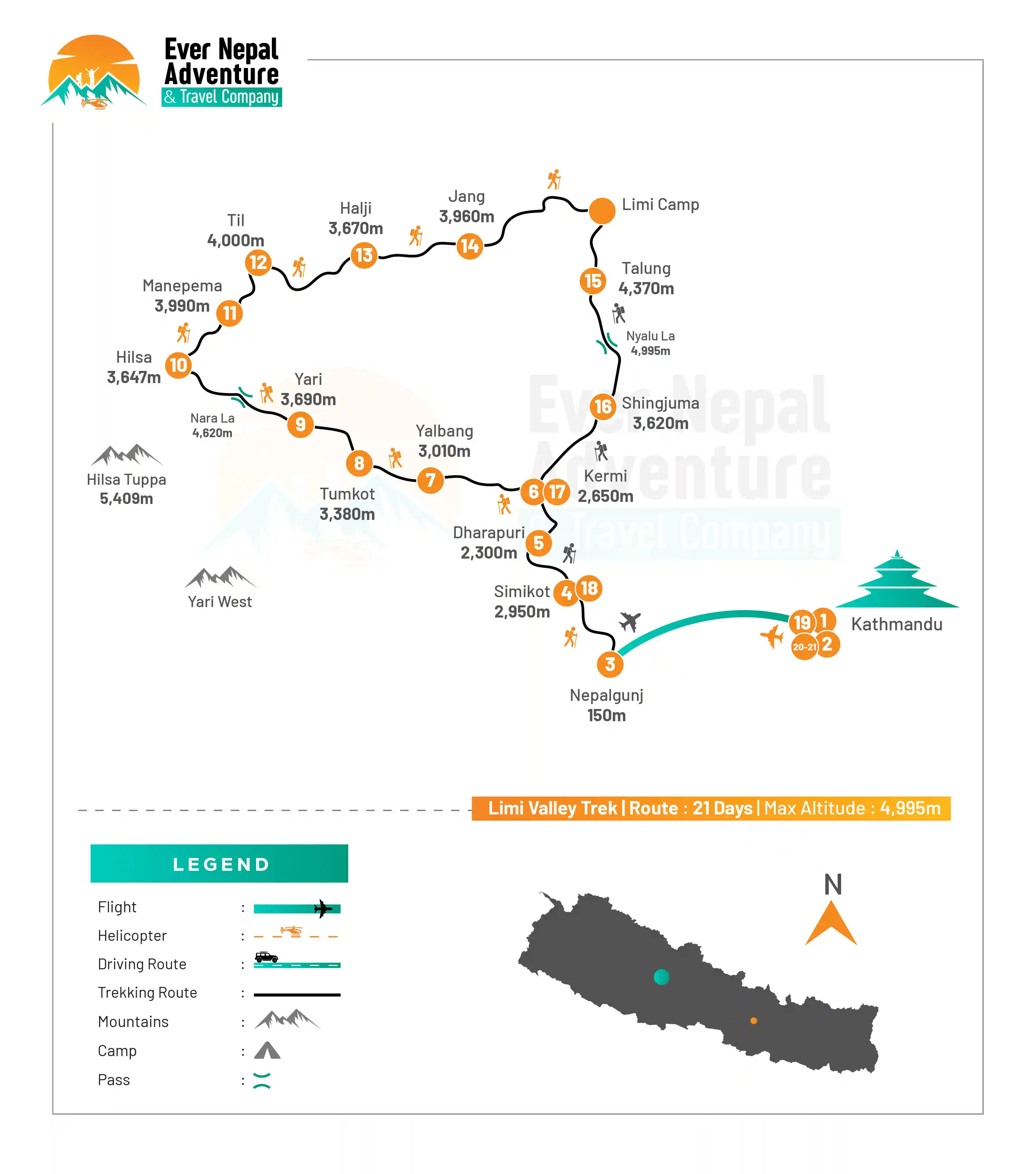
Trek Route

Limi Valley Trek route map

What's included

  • Airport pick-up and drop-off in a private, comfortable vehicle

  • Stay in a 3-star hotel in Kathmandu (twin/double room with breakfast)

  • Accommodation in guesthouses or lodges during the trek (twin/double sharing with breakfast, lunch, and dinner)

  • Farewell dinner with a cultural program

  • All ground transportation as mentioned in the itinerary

  • Round-trip domestic flights between Kathmandu, Nepalgunj, and Simikot

  • Experienced, English-speaking, government-licensed trekking guide (assistant guide if needed)

  • Porter service (1 porter for every 2 trekkers)

  • Safe drinking water during the trek

  • Tea, coffee, and light snacks during trekking days

  • All expenses for staff (salary, insurance, food, accommodation, equipment, and flights)

  • Duffel bag, sleeping bag, T-shirt, and trekking map

  • Restricted Area Permit (Humla / Limi)

  • First aid kit carried by the guide

  • All government taxes and service charges

  • Guaranteed departure (trip runs as scheduled)

What's excluded

  • Nepal visa fees and international flight tickets

  • Travel insurance (must include high-altitude trekking and helicopter rescue)

  • Personal climbing gear (boots, crampons, ice axe, down jacket, etc.)

  • Meals in Kathmandu (except breakfast)

  • Personal expenses (drinks, snacks, hot showers, Wi-Fi, laundry, phone calls)

  • Tips for guides, porters, and support staff

  • Extra nights in Kathmandu due to early arrival, late departure, or flight delays

  • Extra costs due to weather, itinerary changes, or unexpected situations

Packing List for Limi Valley Trek

You need to prepare yourself properly for the Limi Valley Trek in advance. This is because it is situated in an area far from civilization in Nepal. You will face harsh winters on the route and even in a few Alpine regions. It will be easier for you to keep yourself warm and comfortable if you carry the right gear with you. Here are the essentials you should take along with you. 

  • Head

    • Wide-brimmed sun hat

    • Warm woolen beanie

    • Neck gaiter, or buff

    • UV-protected sunglasses

    • High-SPF sunscreen

    • Lip Balm

    • Extra batteries included in the lightweight headlamp

    • Facial wipes

    • Sun cap

    • Wool scarf or fleece headcover

  • Hands

    • Waterproof gloves

    • Insulated Warm Gloves

    • Light inner gloves

    • Hand Warmers

  • Upper Body

    • Thermal base layers

    • T-shirts for trekking that dry quickly

    • Long-sleeved hiking shirt with breathable material

    • Fleece jacket

    • Insulated down jacket

    • Outer jacket that is waterproof and windproof

    • Raincoat or Poncho

    • Lightweight puffy jacket

    • Comfortable trekking hoodie

  • Lower Body

    • Thermal innerwear

    • Full-length trekking trousers

    • Waterproof trekking pants

    • Fleece trekking pants

    • Comfortable cotton pants

    • Warm insulated pants

    • Quick-dry underwear

  • Footwear

    • Waterproof trekking boots that are durable

    • Lightweight sandals and camp shoes

    • Gaiters

    • Wool socks that wick away moisture

    • Light cotton socks

    • Microspikes are optional during the snow season.

  • Toiletries

    • Toothbrushes and toothpaste

    • Biodegradable soap

    • Quick-dry towel

    • Small shampoo bottle

    • Toilet paper

    • Wet wipes

    • Hand sanitizer

    • Moisturizer cream

    • Nail cutter

  • Accessories

    • Sleeping bag suitable for cold temperatures

    • Duffel bag

    • Small daypack or backpack

    • Hydration bladder or water bottle

    • Water purification tablets/filter

    • Trekking poles

    • Rain cover for backpack

    • Dry bags for clothing and electronics

    • Portable solar charger

  • First Aid Kit

    • Diamox

    • Painkillers (ibuprofen/paracetamol)

    • Antiseptic creams or wipes

    • Bandages

    • Blister Treatment Kit

    • Anti-diarrhea medication

    • Prescription medicines for personal use

    • Altitude sickness medication

    • Packets of ORS

  • Miscellaneous Items

    • Camera or mobile phone

    • Power bank

    • Travel adapter

    • Binoculars

    • Journal or notebook

    • Snacks, energy bars, and snacks

    • Photocopies of passports

    • Extra batteries

    • Thermos flasks are lightweight.


  • Special Gears for Women

For comfort and convenience, women trekking in the remote Limi Valley should bring a few personal essentials. It is important to carry enough personal care products, as the facilities in upper mountain villages are limited. Here are a few items that women should bring with them on their trek.

  • Underwear

  • Sports bra

  • Sanitary pads

  • Tampons

  • Skincare products (moisturizers, cleansers, sunscreens)

  • Travel-size shampoo

  • Lip moisturizer

  • Fleece headband

  • Comfortable leggings

  • Personal hygiene products

Documents

To complete the Limi Valley Trek successfully, certain documents are needed. These documents will ensure that you have a hassle-free, safe, and well-managed journey to one of Nepal's remotest restricted regions. Below are the mandatory documents needed for this trek:

  • Humla / Limi Valley Restricted Area Permit (RAP): This is a permit that is required for trekking in Limi Valley, because it falls within a restricted area near the Tibet border. The Department of Immigration, Kathmandu, must issue the permit through a licensed trekking agency. The fee for the first seven days is USD 50 per person and USD 7 each day after that. Solo trekking is not allowed.

  • Makalu Barun / Local Conservation & Rural Municipality (if applicable): Depending on the exact trail and entry/exit point, trekkers might be required to pay entry fees for local rural municipalities or conservation within Humla. The fee is collected in Kathmandu or at the entry checkpoints on the route. The charges vary depending on the region, and they are usually minimal when compared with restricted area permits.

  • Original passport: For the Limi Valley Trek, you will need an original passport valid for at least six months from the date of your entry into Nepal. This document is required for the issuance of all trekking permits as well as for verification on domestic flights. For safety, trekkers should carry digital or photocopies of their documents. 

  • Passport-size photos: Passport-size photos should be carried in numbers ranging from 4 to 6 for the permit and other documentation processes. The photos might be needed at different check posts during your journey on the restricted route. It is suggested to have some extras since the place is pretty isolated.

  • Travel Insurance: Travel insurance is mandatory for the Limi Valley Trek. This insurance should cover high-altitude trekking and travel insurance. Travel insurance is essential, considering that it covers high altitudes and isolation in the case of emergencies requiring an air ambulance evacuation. 

Frequently Asked Questions

Do I require a permit for Limi Valley Trekking?

The Limi Valley Trek does require a permit. The Department of Immigration, Kathmandu, issues this permit through a registered trekking company. Solo trekking is also not permitted. The fee for the permit depends on how many days you spend in the restricted area.

How difficult is Limi Valley Trekking?

Because of the remoteness of the tracks, altitude, and difficulty in the terrain, the Limi Valley Trek can be said to be moderately difficult. This trek takes place at altitudes of up to 5,000 meters, and one must have a reasonable physical fitness level for it. Additionally, the trekking is through difficult terrain with long hours of walking.

When is the best time of year to trek the Limi Valley?

Spring (April to June) and Autumn (September to November) are the best seasons. The weather is generally more stable during these months, and the skies are clearer. The winter is very cold, and snow can block many passes. The monsoon season should be avoided due to landslides and rain.

Is altitude sickness an issue for this tour?

Yes, altitude sickness will be an issue since we will reach a point where we will climb up to almost 5,000 meters above sea level. There are days set aside for acclimatization, but we should not rush up the mountain. We need to take it slow and drink plenty of water. Our guides are trained on how to handle situations that arise due to altitude sickness.

How will I be accommodated on this trekking expedition?

We will be accommodated in teahouses and basic lodges. In some cases, camping will be required since there will not be enough infrastructure to support other means of accommodation. Our rooms will be mostly shared and offer very little comfort. In some places, we might not have hot showers, electricity, or even Wi-Fi connection. You can find a variety of food, including dal bhat (noodles), rice, soups, and potatoes. As you ascend into the remote villages, menu options are more limited. Food choices should be flexible for trekkers.

Is the Limi Valley Trek suitable for Beginners?

Considering the elevation and remoteness of the places, this trek is not suitable for beginners at all. Beginner trekkers require some level of trekking experience or fitness training before taking up this trek because there will be numerous walking days on the itinerary without any facilities. Beginners should avoid this trek without adequate training and should only do it under guidance.

Is it cold when I’m trekking?

The climate of high altitudes becomes very cold, irrespective of the season. During the trekking period, nights tend to get very chilly. The wind chill at passes like Nyalu La can cause freezing. Layers of clothes are necessary to maintain warmth and comfort.

Am I able to use the phone and the internet?

Network connectivity is difficult and unavailable in most regions of the Limi Valley Trek. In lower regions, mobile network connectivity may be possible, while in higher regions, lack of network connectivity. Similarly, internet connectivity is impossible throughout the trekking period.

What are the things that I should prepare for the Limi Valley Trekking?

It is important for one to have various clothes, waterproof equipment, and suitable hiking shoes. It is necessary for one to have a good sleeping bag to endure a cold environment. Other important items that should be packed include sunscreen, sunglasses, gloves, and a medical kit.

User Review